You are here: Home > Network List > UU - University of Utah Regional Network Stations List
> Station MTPU Mt. Pierson, UT, USA > Earthquake Result Viewer
MTPU Mt. Pierson, UT, USA - Earthquake Result Viewer
| Earthquake location: |
Tonga Islands |
| Earthquake latitude/longitude: |
-19.4/-174.9 |
| Earthquake time(UTC): |
2019/08/05 (217) 09:01:08 GMT |
| Earthquake Depth: |
10 km |
| Earthquake Magnitude: |
5.7 mb |
| Earthquake Catalog/Contributor: |
NEIC PDE/us |
|
| Network: |
UU University of Utah Regional Network |
| Station: |
MTPU Mt. Pierson, UT, USA |
| Lat/Lon: |
38.04 N/112.18 W |
| Elevation: |
3112 m |
|
| Distance: |
82.0 deg |
| Az: |
45.117 deg |
| Baz: |
237.919 deg |
| Ray Param: |
0.047218673 |
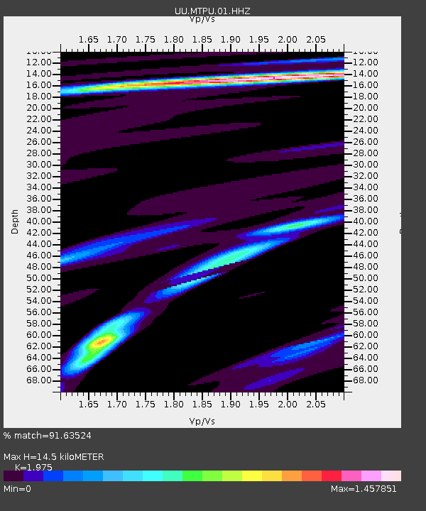
| Estimated Moho Depth: |
14.5 km |
| Estimated Crust Vp/Vs: |
1.98 |
| Assumed Crust Vp: |
6.276 km/s |
| Estimated Crust Vs: |
3.178 km/s |
| Estimated Crust Poisson's Ratio: |
0.33 |
|
| Radial Match: |
91.63524 % |
| Radial Bump: |
290 |
| Transverse Match: |
89.16819 % |
| Transverse Bump: |
333 |
| SOD ConfigId: |
19053131 |
| Insert Time: |
2019-08-19 09:14:30.316 +0000 |
| GWidth: |
2.5 |
| Max Bumps: |
400 |
| Tol: |
0.001 |
|

Signal To Noise
| Channel | StoN | STA | LTA |
| UU:MTPU:01:HHZ:20190805T09:12:56.988021Z | 17.367672 | 4.434071E-8 | 2.55306E-9 |
| UU:MTPU:01:HHN:20190805T09:12:56.988021Z | 6.3569946 | 7.545567E-9 | 1.1869709E-9 |
| UU:MTPU:01:HHE:20190805T09:12:56.988021Z | 5.7635746 | 1.4275152E-8 | 2.4767879E-9 |
| Arrivals |
| Ps | 2.3 SECOND |
| PpPs | 6.7 SECOND |
| PsPs/PpSs | 9.0 SECOND |


