You are here: Home > Network List > UU - University of Utah Regional Network Stations List
> Station VRUT Veyo Road, Veyo, UT, USA > Earthquake Result Viewer
VRUT Veyo Road, Veyo, UT, USA - Earthquake Result Viewer
| Earthquake location: |
Tonga Islands |
| Earthquake latitude/longitude: |
-19.4/-174.9 |
| Earthquake time(UTC): |
2019/08/05 (217) 09:01:08 GMT |
| Earthquake Depth: |
10 km |
| Earthquake Magnitude: |
5.7 mb |
| Earthquake Catalog/Contributor: |
NEIC PDE/us |
|
| Network: |
UU University of Utah Regional Network |
| Station: |
VRUT Veyo Road, Veyo, UT, USA |
| Lat/Lon: |
37.46 N/113.86 W |
| Elevation: |
1874 m |
|
| Distance: |
80.5 deg |
| Az: |
44.887 deg |
| Baz: |
236.865 deg |
| Ray Param: |
0.04821145 |
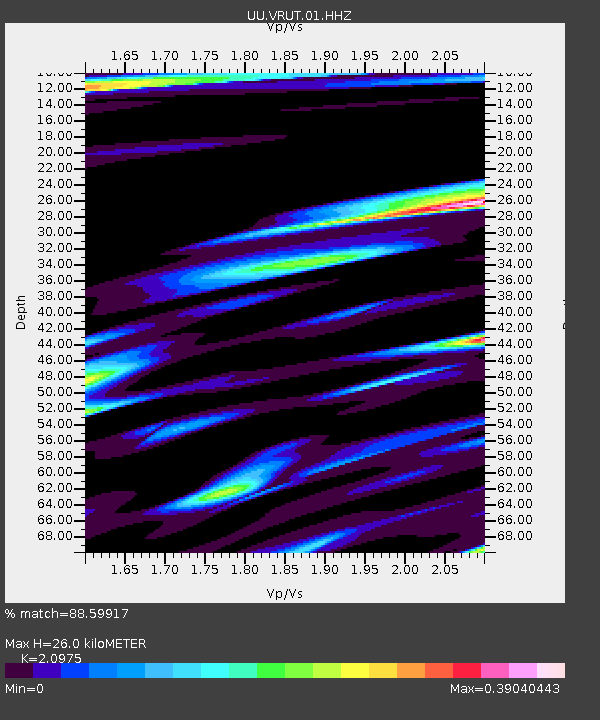
| Estimated Moho Depth: |
26.0 km |
| Estimated Crust Vp/Vs: |
2.10 |
| Assumed Crust Vp: |
6.194 km/s |
| Estimated Crust Vs: |
2.953 km/s |
| Estimated Crust Poisson's Ratio: |
0.35 |
|
| Radial Match: |
88.59917 % |
| Radial Bump: |
318 |
| Transverse Match: |
74.858 % |
| Transverse Bump: |
400 |
| SOD ConfigId: |
19053131 |
| Insert Time: |
2019-08-19 09:14:37.203 +0000 |
| GWidth: |
2.5 |
| Max Bumps: |
400 |
| Tol: |
0.001 |
|

Signal To Noise
| Channel | StoN | STA | LTA |
| UU:VRUT:01:HHZ:20190805T09:12:49.429977Z | 11.032458 | 3.4425106E-8 | 3.1203478E-9 |
| UU:VRUT:01:HHN:20190805T09:12:49.429977Z | 4.4465375 | 7.515368E-9 | 1.6901618E-9 |
| UU:VRUT:01:HHE:20190805T09:12:49.429977Z | 9.2167845 | 8.881934E-9 | 9.636696E-10 |
| Arrivals |
| Ps | 4.7 SECOND |
| PpPs | 13 SECOND |
| PsPs/PpSs | 17 SECOND |


