You are here: Home > Network List > UW - Pacific Northwest Regional Seismic Network Stations List
> Station UMAT Pilot Rock, OR, USA > Earthquake Result Viewer
UMAT Pilot Rock, OR, USA - Earthquake Result Viewer
| Earthquake location: |
Tonga Islands |
| Earthquake latitude/longitude: |
-19.4/-174.9 |
| Earthquake time(UTC): |
2019/08/05 (217) 09:01:08 GMT |
| Earthquake Depth: |
10 km |
| Earthquake Magnitude: |
5.7 mb |
| Earthquake Catalog/Contributor: |
NEIC PDE/us |
|
| Network: |
UW Pacific Northwest Regional Seismic Network |
| Station: |
UMAT Pilot Rock, OR, USA |
| Lat/Lon: |
45.29 N/118.96 W |
| Elevation: |
1318 m |
|
| Distance: |
81.9 deg |
| Az: |
36.191 deg |
| Baz: |
232.168 deg |
| Ray Param: |
0.04723137 |
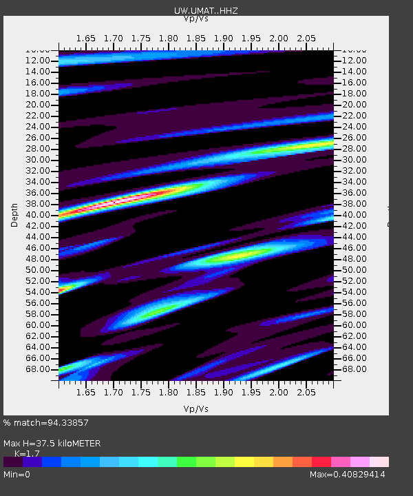
| Estimated Moho Depth: |
37.5 km |
| Estimated Crust Vp/Vs: |
1.70 |
| Assumed Crust Vp: |
6.571 km/s |
| Estimated Crust Vs: |
3.865 km/s |
| Estimated Crust Poisson's Ratio: |
0.24 |
|
| Radial Match: |
94.33857 % |
| Radial Bump: |
244 |
| Transverse Match: |
90.16592 % |
| Transverse Bump: |
336 |
| SOD ConfigId: |
19053131 |
| Insert Time: |
2019-08-19 09:14:59.670 +0000 |
| GWidth: |
2.5 |
| Max Bumps: |
400 |
| Tol: |
0.001 |
|

Signal To Noise
| Channel | StoN | STA | LTA |
| UW:UMAT: :HHZ:20190805T09:12:56.897994Z | 10.077398 | 1.2068233E-6 | 1.1975544E-7 |
| UW:UMAT: :HHN:20190805T09:12:56.897994Z | 7.1753335 | 2.4970362E-7 | 3.480028E-8 |
| UW:UMAT: :HHE:20190805T09:12:56.897994Z | 12.072563 | 4.3751865E-7 | 3.6240742E-8 |
| Arrivals |
| Ps | 4.1 SECOND |
| PpPs | 15 SECOND |
| PsPs/PpSs | 19 SECOND |


