You are here: Home > Network List > TA - USArray Transportable Network (new EarthScope stations) Stations List
> Station E06A Yakima, WA, USA > Earthquake Result Viewer
E06A Yakima, WA, USA - Earthquake Result Viewer
| Earthquake location: |
South Of Mariana Islands |
| Earthquake latitude/longitude: |
10.5/145.7 |
| Earthquake time(UTC): |
2007/09/30 (273) 02:08:30 GMT |
| Earthquake Depth: |
14 km |
| Earthquake Magnitude: |
6.4 MB, 7.1 MS, 6.9 MW, 6.9 MW |
| Earthquake Catalog/Contributor: |
WHDF/NEIC |
|
| Network: |
TA USArray Transportable Network (new EarthScope stations) |
| Station: |
E06A Yakima, WA, USA |
| Lat/Lon: |
46.54 N/120.98 W |
| Elevation: |
911 m |
|
| Distance: |
84.8 deg |
| Az: |
43.787 deg |
| Baz: |
279.563 deg |
| Ray Param: |
0.045244493 |
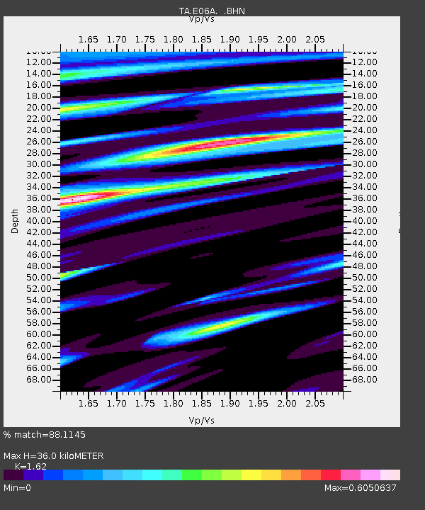
| Estimated Moho Depth: |
36.0 km |
| Estimated Crust Vp/Vs: |
1.62 |
| Assumed Crust Vp: |
6.597 km/s |
| Estimated Crust Vs: |
4.073 km/s |
| Estimated Crust Poisson's Ratio: |
0.19 |
|
| Radial Match: |
88.1145 % |
| Radial Bump: |
400 |
| Transverse Match: |
80.419235 % |
| Transverse Bump: |
400 |
| SOD ConfigId: |
2564 |
| Insert Time: |
2010-03-07 02:54:17.460 +0000 |
| GWidth: |
2.5 |
| Max Bumps: |
400 |
| Tol: |
0.001 |
|
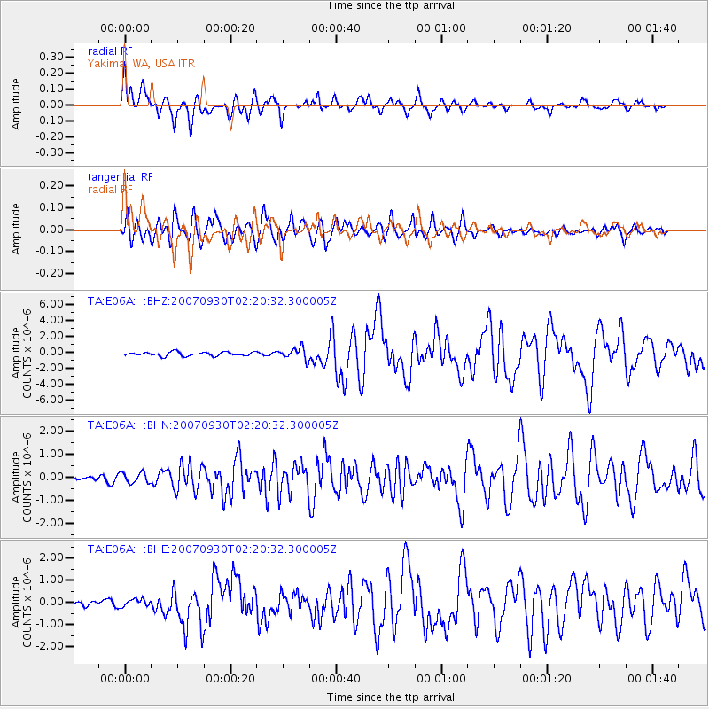
Signal To Noise
| Channel | StoN | STA | LTA |
| TA:E06A: :BHN:20070930T02:20:32.300005Z | 2.7304916 | 2.2937833E-7 | 8.400624E-8 |
| TA:E06A: :BHE:20070930T02:20:32.300005Z | 1.3130141 | 1.6978404E-7 | 1.2930862E-7 |
| TA:E06A: :BHZ:20070930T02:20:32.300005Z | 3.0344744 | 7.472082E-7 | 2.4623975E-7 |
| Arrivals |
| Ps | 3.5 SECOND |
| PpPs | 14 SECOND |
| PsPs/PpSs | 17 SECOND |


