You are here: Home > Network List > TA - USArray Transportable Network (new EarthScope stations) Stations List
> Station E06A Yakima, WA, USA > Earthquake Result Viewer
E06A Yakima, WA, USA - Earthquake Result Viewer
| Earthquake location: |
Near Coast Of Peru |
| Earthquake latitude/longitude: |
-14.3/-76.1 |
| Earthquake time(UTC): |
2007/08/16 (228) 05:16:56 GMT |
| Earthquake Depth: |
23 km |
| Earthquake Magnitude: |
5.8 MB, 6.1 MS, 6.3 MW, 6.2 ML |
| Earthquake Catalog/Contributor: |
WHDF/NEIC |
|
| Network: |
TA USArray Transportable Network (new EarthScope stations) |
| Station: |
E06A Yakima, WA, USA |
| Lat/Lon: |
46.54 N/120.98 W |
| Elevation: |
911 m |
|
| Distance: |
72.7 deg |
| Az: |
329.348 deg |
| Baz: |
134.269 deg |
| Ray Param: |
0.05344746 |
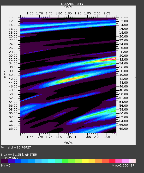
| Estimated Moho Depth: |
31.25 km |
| Estimated Crust Vp/Vs: |
2.10 |
| Assumed Crust Vp: |
6.597 km/s |
| Estimated Crust Vs: |
3.149 km/s |
| Estimated Crust Poisson's Ratio: |
0.35 |
|
| Radial Match: |
86.76927 % |
| Radial Bump: |
400 |
| Transverse Match: |
74.43984 % |
| Transverse Bump: |
400 |
| SOD ConfigId: |
2564 |
| Insert Time: |
2010-03-07 02:54:25.286 +0000 |
| GWidth: |
2.5 |
| Max Bumps: |
400 |
| Tol: |
0.001 |
|

Signal To Noise
| Channel | StoN | STA | LTA |
| TA:E06A: :BHN:20070816T05:27:51.025Z | 1.2818894 | 1.4079231E-7 | 1.0983186E-7 |
| TA:E06A: :BHE:20070816T05:27:51.025Z | 3.7663202 | 3.0384177E-7 | 8.0673374E-8 |
| TA:E06A: :BHZ:20070816T05:27:51.025Z | 3.565814 | 6.3818857E-7 | 1.7897418E-7 |
| Arrivals |
| Ps | 5.3 SECOND |
| PpPs | 14 SECOND |
| PsPs/PpSs | 20 SECOND |


