You are here: Home > Network List > TA - USArray Transportable Network (new EarthScope stations) Stations List
> Station E06A Yakima, WA, USA > Earthquake Result Viewer
E06A Yakima, WA, USA - Earthquake Result Viewer
| Earthquake location: |
Northern Mid-Atlantic Ridge |
| Earthquake latitude/longitude: |
25.9/-45.0 |
| Earthquake time(UTC): |
2007/08/09 (221) 17:25:05 GMT |
| Earthquake Depth: |
10 km |
| Earthquake Magnitude: |
5.6 MW, 5.1 MS, 5.2 MB |
| Earthquake Catalog/Contributor: |
WHDF/NEIC |
|
| Network: |
TA USArray Transportable Network (new EarthScope stations) |
| Station: |
E06A Yakima, WA, USA |
| Lat/Lon: |
46.54 N/120.98 W |
| Elevation: |
911 m |
|
| Distance: |
62.3 deg |
| Az: |
310.844 deg |
| Baz: |
80.758 deg |
| Ray Param: |
0.06033128 |
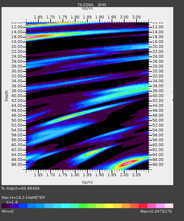
| Estimated Moho Depth: |
16.0 km |
| Estimated Crust Vp/Vs: |
1.60 |
| Assumed Crust Vp: |
6.597 km/s |
| Estimated Crust Vs: |
4.123 km/s |
| Estimated Crust Poisson's Ratio: |
0.18 |
|
| Radial Match: |
84.99488 % |
| Radial Bump: |
400 |
| Transverse Match: |
79.81017 % |
| Transverse Bump: |
400 |
| SOD ConfigId: |
2564 |
| Insert Time: |
2010-03-07 02:54:30.147 +0000 |
| GWidth: |
2.5 |
| Max Bumps: |
400 |
| Tol: |
0.001 |
|

Signal To Noise
| Channel | StoN | STA | LTA |
| TA:E06A: :BHN:20070809T17:34:56.148018Z | 1.4463717 | 8.2595065E-8 | 5.7105005E-8 |
| TA:E06A: :BHE:20070809T17:34:56.148018Z | 4.832718 | 2.3962625E-7 | 4.958416E-8 |
| TA:E06A: :BHZ:20070809T17:34:56.148018Z | 10.946278 | 5.5272375E-7 | 5.0494222E-8 |
| Arrivals |
| Ps | 1.5 SECOND |
| PpPs | 6.0 SECOND |
| PsPs/PpSs | 7.5 SECOND |


