You are here: Home > Network List > US - United States National Seismic Network Stations List
> Station DGMT Dagmar, Montana, USA > Earthquake Result Viewer
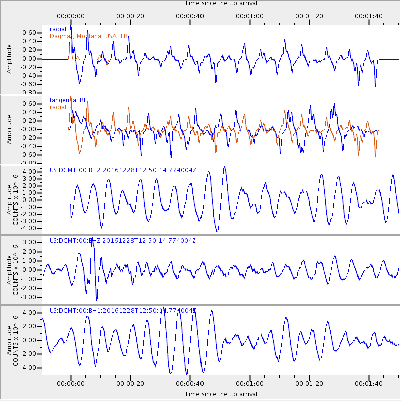
DGMT Dagmar, Montana, USA - Earthquake Result Viewer
*The percent match for this event was below the threshold and hence no stack was calculated.
| Earthquake location: |
Near East Coast Of Honshu, Japan |
| Earthquake latitude/longitude: |
36.9/140.4 |
| Earthquake time(UTC): |
2016/12/28 (363) 12:38:50 GMT |
| Earthquake Depth: |
10 km |
| Earthquake Magnitude: |
5.9 Mww |
| Earthquake Catalog/Contributor: |
NEIC PDE/us |
|
| Network: |
US United States National Seismic Network |
| Station: |
DGMT Dagmar, Montana, USA |
| Lat/Lon: |
48.47 N/104.20 W |
| Elevation: |
0.0 m |
|
| Distance: |
77.4 deg |
| Az: |
38.03 deg |
| Baz: |
312.106 deg |
| Ray Param: |
$rayparam |
*The percent match for this event was below the threshold and hence was not used in the summary stack. |
|
| Radial Match: |
54.995537 % |
| Radial Bump: |
335 |
| Transverse Match: |
53.969517 % |
| Transverse Bump: |
273 |
| SOD ConfigId: |
1943534 |
| Insert Time: |
2017-01-11 12:41:35.492 +0000 |
| GWidth: |
2.5 |
| Max Bumps: |
400 |
| Tol: |
0.001 |
|
Signal To Noise
| Channel | StoN | STA | LTA |
| US:DGMT:00:BHZ:20161228T12:50:14.774004Z | 2.3189344 | 1.1750931E-6 | 5.067384E-7 |
| US:DGMT:00:BH1:20161228T12:50:14.774004Z | 1.0184635 | 1.9470967E-6 | 1.911798E-6 |
| US:DGMT:00:BH2:20161228T12:50:14.774004Z | 0.8491897 | 1.4277068E-6 | 1.6812579E-6 |
| Arrivals |
| Ps | |
| PpPs | |
| PsPs/PpSs | |


