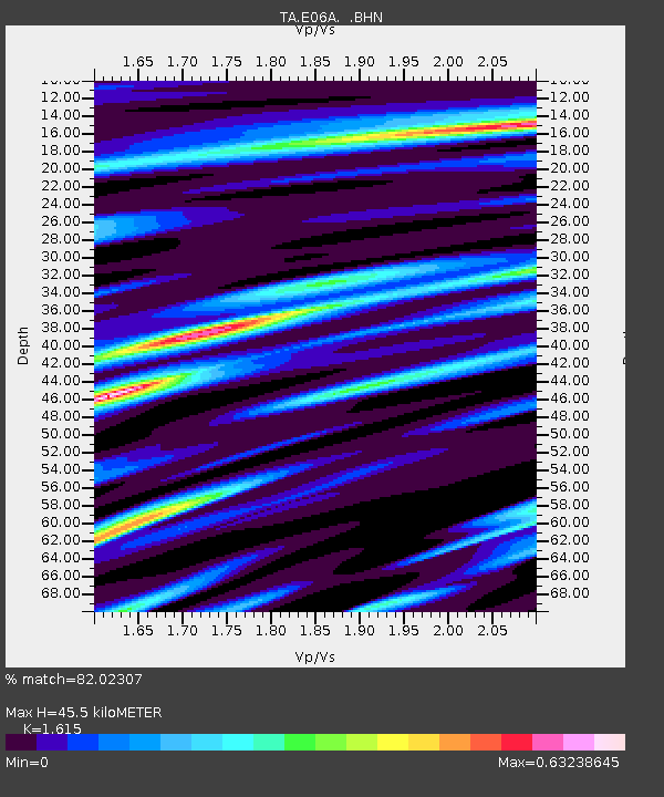
E06A Yakima, WA, USA - Earthquake Result Viewer
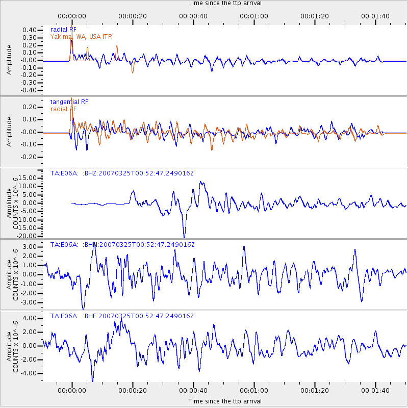
Earthquake location: Near West Coast Of Honshu, Japan
Earthquake latitude/longitude: 37.3/136.6
Earthquake time(UTC): 2007/03/25 (084) 00:41:57 GMT
Earthquake Depth: 8.0 km
Earthquake Magnitude: 6.1 MB, 6.8 MS, 6.7 MW, 6.6 MW
Earthquake Catalog/Contributor: WHDF/NEIC
Network: TA USArray Transportable Network (new EarthScope stations)
Station: E06A Yakima, WA, USA
Lat/Lon: 46.54 N/120.98 W
Elevation: 911 m
Distance: 71.4 deg
Az: 45.324 deg
Baz: 304.802 deg
Ray Param: 0.05434055
Estimated Moho Depth: 45.5 km
Estimated Crust Vp/Vs: 1.62
Assumed Crust Vp: 6.597 km/s
Estimated Crust Vs: 4.085 km/s
Estimated Crust Poisson's Ratio: 0.19
Radial Match: 82.02307 %
Radial Bump: 400
Transverse Match: 75.97719 %
Transverse Bump: 400
SOD ConfigId: 2564
Insert Time: 2010-03-07 02:54:40.667 +0000
GWidth: 2.5
Max Bumps: 400
Tol: 0.001

Signal To Noise

ChannelStoNSTALTA
TA:E06A: :BHN:20070325T00:52:47.249016Z4.872381.7362859E-63.5635276E-7
TA:E06A: :BHE:20070325T00:52:47.249016Z2.57338671.3741108E-65.339698E-7
TA:E06A: :BHZ:20070325T00:52:47.249016Z3.02647525.030418E-61.6621375E-6
Arrivals
Ps4.4 SECOND
PpPs17 SECOND
PsPs/PpSs22 SECOND