You are here: Home > Network List > TA - USArray Transportable Network (new EarthScope stations) Stations List
> Station E06A Yakima, WA, USA > Earthquake Result Viewer
E06A Yakima, WA, USA - Earthquake Result Viewer
| Earthquake location: |
South Of Panama |
| Earthquake latitude/longitude: |
4.6/-78.5 |
| Earthquake time(UTC): |
2007/03/18 (077) 02:11:05 GMT |
| Earthquake Depth: |
8.0 km |
| Earthquake Magnitude: |
6.4 MB, 5.7 MS, 6.2 MW, 6.1 MW |
| Earthquake Catalog/Contributor: |
WHDF/NEIC |
|
| Network: |
TA USArray Transportable Network (new EarthScope stations) |
| Station: |
E06A Yakima, WA, USA |
| Lat/Lon: |
46.54 N/120.98 W |
| Elevation: |
911 m |
|
| Distance: |
55.6 deg |
| Az: |
325.605 deg |
| Baz: |
125.332 deg |
| Ray Param: |
0.06469088 |
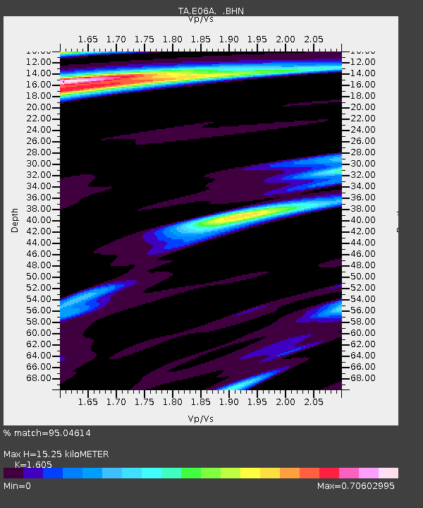
| Estimated Moho Depth: |
15.25 km |
| Estimated Crust Vp/Vs: |
1.61 |
| Assumed Crust Vp: |
6.597 km/s |
| Estimated Crust Vs: |
4.111 km/s |
| Estimated Crust Poisson's Ratio: |
0.18 |
|
| Radial Match: |
95.04614 % |
| Radial Bump: |
394 |
| Transverse Match: |
85.32065 % |
| Transverse Bump: |
400 |
| SOD ConfigId: |
2564 |
| Insert Time: |
2010-03-07 02:54:44.069 +0000 |
| GWidth: |
2.5 |
| Max Bumps: |
400 |
| Tol: |
0.001 |
|
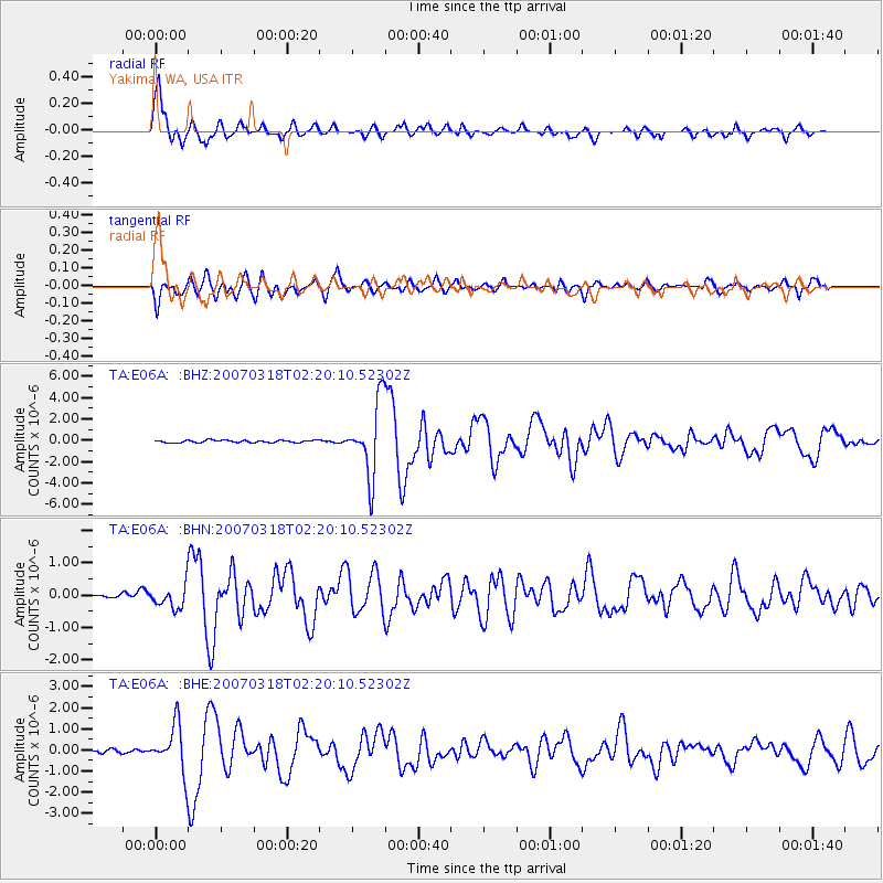
Signal To Noise
| Channel | StoN | STA | LTA |
| TA:E06A: :BHN:20070318T02:20:10.52302Z | 1.7784511 | 3.5100553E-7 | 1.9736585E-7 |
| TA:E06A: :BHE:20070318T02:20:10.52302Z | 6.901299 | 1.0968339E-6 | 1.5893151E-7 |
| TA:E06A: :BHZ:20070318T02:20:10.52302Z | 29.501692 | 3.3970853E-6 | 1.1514882E-7 |
| Arrivals |
| Ps | 1.5 SECOND |
| PpPs | 5.7 SECOND |
| PsPs/PpSs | 7.2 SECOND |


