You are here: Home > Network List > TA - USArray Transportable Network (new EarthScope stations) Stations List
> Station E06A Yakima, WA, USA > Earthquake Result Viewer
E06A Yakima, WA, USA - Earthquake Result Viewer
| Earthquake location: |
East Of Kuril Islands |
| Earthquake latitude/longitude: |
46.2/154.5 |
| Earthquake time(UTC): |
2007/01/13 (013) 04:23:21 GMT |
| Earthquake Depth: |
10 km |
| Earthquake Magnitude: |
7.3 MB, 8.2 MS, 8.1 MW, 7.9 MW |
| Earthquake Catalog/Contributor: |
WHDF/NEIC |
|
| Network: |
TA USArray Transportable Network (new EarthScope stations) |
| Station: |
E06A Yakima, WA, USA |
| Lat/Lon: |
46.54 N/120.98 W |
| Elevation: |
911 m |
|
| Distance: |
55.5 deg |
| Az: |
56.513 deg |
| Baz: |
303.009 deg |
| Ray Param: |
0.064774595 |
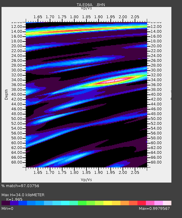
| Estimated Moho Depth: |
34.0 km |
| Estimated Crust Vp/Vs: |
1.97 |
| Assumed Crust Vp: |
6.597 km/s |
| Estimated Crust Vs: |
3.358 km/s |
| Estimated Crust Poisson's Ratio: |
0.33 |
|
| Radial Match: |
97.03756 % |
| Radial Bump: |
352 |
| Transverse Match: |
87.68002 % |
| Transverse Bump: |
400 |
| SOD ConfigId: |
2564 |
| Insert Time: |
2010-03-07 02:54:45.634 +0000 |
| GWidth: |
2.5 |
| Max Bumps: |
400 |
| Tol: |
0.001 |
|

Signal To Noise
| Channel | StoN | STA | LTA |
| TA:E06A: :BHN:20070113T04:32:24.899014Z | 3.1657262 | 7.852799E-7 | 2.4805678E-7 |
| TA:E06A: :BHE:20070113T04:32:24.899014Z | 5.707617 | 9.907365E-7 | 1.7358145E-7 |
| TA:E06A: :BHZ:20070113T04:32:24.899014Z | 10.727281 | 2.3347343E-6 | 2.1764457E-7 |
| Arrivals |
| Ps | 5.2 SECOND |
| PpPs | 15 SECOND |
| PsPs/PpSs | 20 SECOND |


