You are here: Home > Network List > TA - USArray Transportable Network (new EarthScope stations) Stations List
> Station D23K Nanushuk River, AK USA > Earthquake Result Viewer
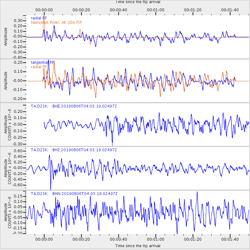
D23K Nanushuk River, AK USA - Earthquake Result Viewer
*The percent match for this event was below the threshold and hence no stack was calculated.
| Earthquake location: |
Northern Molucca Sea |
| Earthquake latitude/longitude: |
2.2/126.5 |
| Earthquake time(UTC): |
2019/08/06 (218) 03:51:16 GMT |
| Earthquake Depth: |
32 km |
| Earthquake Magnitude: |
5.2 Mww |
| Earthquake Catalog/Contributor: |
NEIC PDE/us |
|
| Network: |
TA USArray Transportable Network (new EarthScope stations) |
| Station: |
D23K Nanushuk River, AK USA |
| Lat/Lon: |
68.97 N/150.68 W |
| Elevation: |
406 m |
|
| Distance: |
85.4 deg |
| Az: |
21.06 deg |
| Baz: |
264.059 deg |
| Ray Param: |
$rayparam |
*The percent match for this event was below the threshold and hence was not used in the summary stack. |
|
| Radial Match: |
64.96151 % |
| Radial Bump: |
400 |
| Transverse Match: |
60.766125 % |
| Transverse Bump: |
400 |
| SOD ConfigId: |
19053131 |
| Insert Time: |
2019-08-20 03:54:37.368 +0000 |
| GWidth: |
2.5 |
| Max Bumps: |
400 |
| Tol: |
0.001 |
|
Signal To Noise
| Channel | StoN | STA | LTA |
| TA:D23K: :BHZ:20190806T04:03:19.02497Z | 3.1604233 | 2.3245116E-7 | 7.3550645E-8 |
| TA:D23K: :BHN:20190806T04:03:19.02497Z | 0.8368568 | 4.800532E-8 | 5.736384E-8 |
| TA:D23K: :BHE:20190806T04:03:19.02497Z | 1.8306863 | 7.39592E-8 | 4.0399712E-8 |
| Arrivals |
| Ps | |
| PpPs | |
| PsPs/PpSs | |


