You are here: Home > Network List > G - GEOSCOPE Stations List
> Station DZM Dzumac, New Caledonia > Earthquake Result Viewer
DZM Dzumac, New Caledonia - Earthquake Result Viewer
| Earthquake location: |
Sumbawa Region, Indonesia |
| Earthquake latitude/longitude: |
-9.1/118.6 |
| Earthquake time(UTC): |
2016/12/29 (364) 22:30:18 GMT |
| Earthquake Depth: |
72 km |
| Earthquake Magnitude: |
6.2 Mwp |
| Earthquake Catalog/Contributor: |
NEIC PDE/us |
|
| Network: |
G GEOSCOPE |
| Station: |
DZM Dzumac, New Caledonia |
| Lat/Lon: |
22.07 S/166.44 E |
| Elevation: |
878 m |
|
| Distance: |
47.7 deg |
| Az: |
111.55 deg |
| Baz: |
277.969 deg |
| Ray Param: |
0.06963313 |
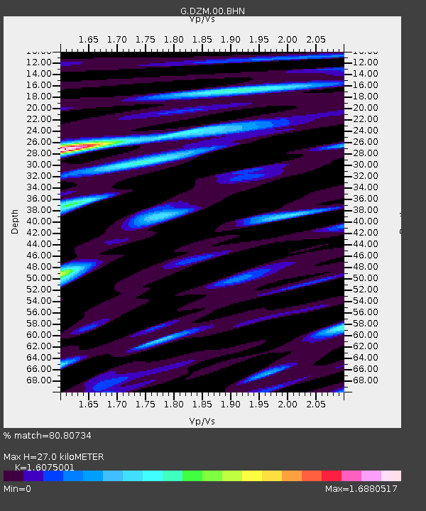
| Estimated Moho Depth: |
27.0 km |
| Estimated Crust Vp/Vs: |
1.61 |
| Assumed Crust Vp: |
5.14 km/s |
| Estimated Crust Vs: |
3.198 km/s |
| Estimated Crust Poisson's Ratio: |
0.18 |
|
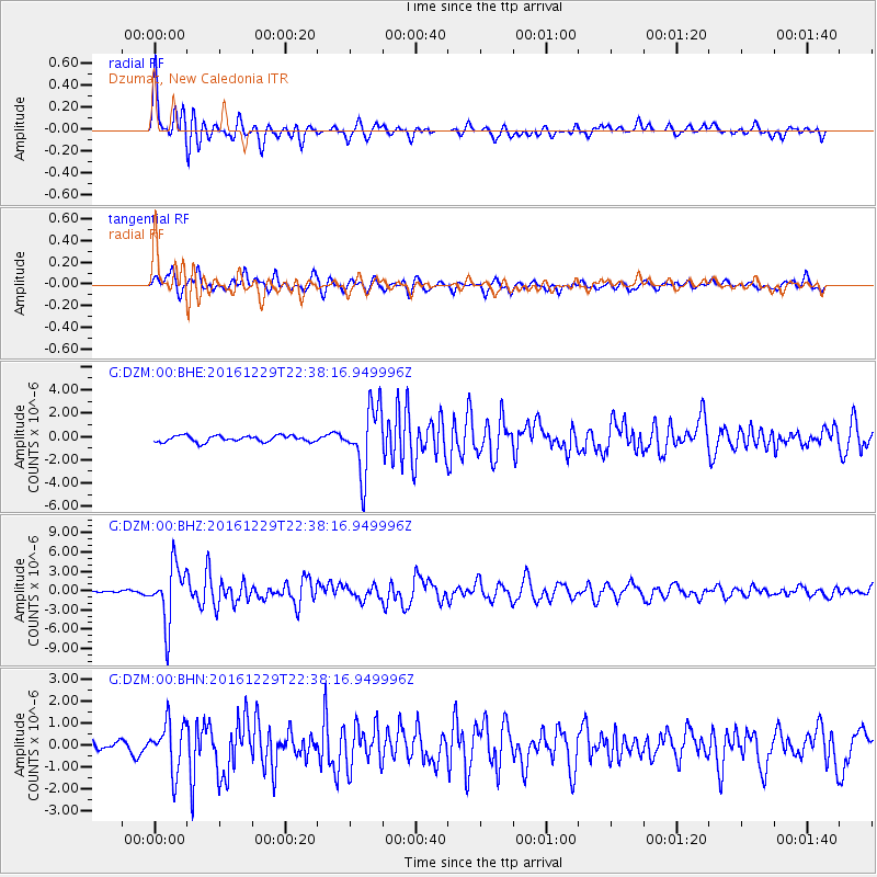
| Radial Match: |
80.80734 % |
| Radial Bump: |
400 |
| Transverse Match: |
62.682182 % |
| Transverse Bump: |
400 |
| SOD ConfigId: |
1943534 |
| Insert Time: |
2017-01-12 22:30:40.296 +0000 |
| GWidth: |
2.5 |
| Max Bumps: |
400 |
| Tol: |
0.001 |
|
Signal To Noise
| Channel | StoN | STA | LTA |
| G:DZM:00:BHZ:20161229T22:38:16.949996Z | 12.418661 | 4.4654926E-6 | 3.5957925E-7 |
| G:DZM:00:BHN:20161229T22:38:16.949996Z | 3.431157 | 1.1071963E-6 | 3.2268892E-7 |
| G:DZM:00:BHE:20161229T22:38:16.949996Z | 10.524341 | 2.8229974E-6 | 2.6823508E-7 |
| Arrivals |
| Ps | 3.3 SECOND |
| PpPs | 13 SECOND |
| PsPs/PpSs | 16 SECOND |


