You are here: Home > Network List > II - Global Seismograph Network (GSN - IRIS/IDA) Stations List
> Station ABPO Ambohimpanompo, Madagascar > Earthquake Result Viewer
ABPO Ambohimpanompo, Madagascar - Earthquake Result Viewer
| Earthquake location: |
Sumbawa Region, Indonesia |
| Earthquake latitude/longitude: |
-9.1/118.6 |
| Earthquake time(UTC): |
2016/12/29 (364) 22:30:18 GMT |
| Earthquake Depth: |
72 km |
| Earthquake Magnitude: |
6.2 Mwp |
| Earthquake Catalog/Contributor: |
NEIC PDE/us |
|
| Network: |
II Global Seismograph Network (GSN - IRIS/IDA) |
| Station: |
ABPO Ambohimpanompo, Madagascar |
| Lat/Lon: |
19.02 S/47.23 E |
| Elevation: |
1528 m |
|
| Distance: |
69.6 deg |
| Az: |
253.086 deg |
| Baz: |
92.811 deg |
| Ray Param: |
0.055390798 |
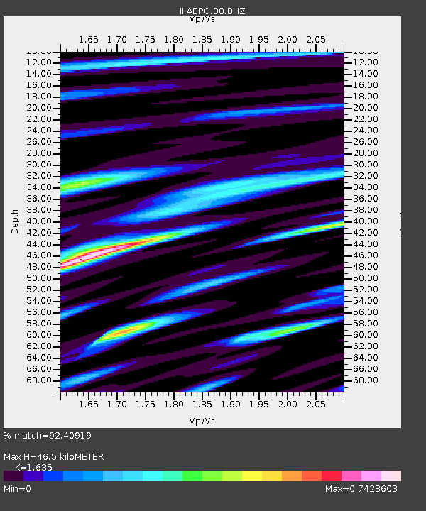
| Estimated Moho Depth: |
46.5 km |
| Estimated Crust Vp/Vs: |
1.63 |
| Assumed Crust Vp: |
6.642 km/s |
| Estimated Crust Vs: |
4.062 km/s |
| Estimated Crust Poisson's Ratio: |
0.20 |
|
| Radial Match: |
92.40919 % |
| Radial Bump: |
400 |
| Transverse Match: |
82.94428 % |
| Transverse Bump: |
400 |
| SOD ConfigId: |
1943534 |
| Insert Time: |
2017-01-12 22:30:58.397 +0000 |
| GWidth: |
2.5 |
| Max Bumps: |
400 |
| Tol: |
0.001 |
|
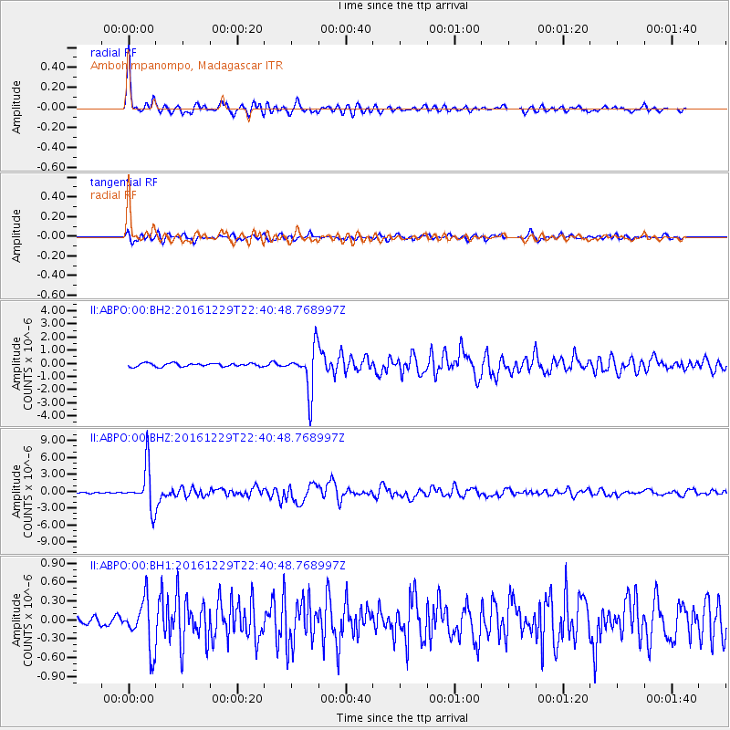
Signal To Noise
| Channel | StoN | STA | LTA |
| II:ABPO:00:BHZ:20161229T22:40:48.768997Z | 69.78525 | 3.7947138E-6 | 5.437702E-8 |
| II:ABPO:00:BH1:20161229T22:40:48.768997Z | 3.51143 | 3.925502E-7 | 1.1179211E-7 |
| II:ABPO:00:BH2:20161229T22:40:48.768997Z | 13.697842 | 1.6981966E-6 | 1.2397548E-7 |
| Arrivals |
| Ps | 4.6 SECOND |
| PpPs | 18 SECOND |
| PsPs/PpSs | 22 SECOND |


