You are here: Home > Network List > IU - Global Seismograph Network (GSN - IRIS/USGS) Stations List
> Station FURI Mt. Furi, Ethiopia > Earthquake Result Viewer
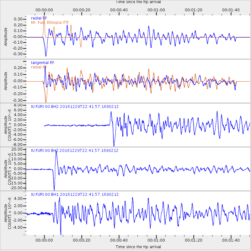
FURI Mt. Furi, Ethiopia - Earthquake Result Viewer
*The percent match for this event was below the threshold and hence no stack was calculated.
| Earthquake location: |
Sumbawa Region, Indonesia |
| Earthquake latitude/longitude: |
-9.1/118.6 |
| Earthquake time(UTC): |
2016/12/29 (364) 22:30:18 GMT |
| Earthquake Depth: |
72 km |
| Earthquake Magnitude: |
6.2 Mwp |
| Earthquake Catalog/Contributor: |
NEIC PDE/us |
|
| Network: |
IU Global Seismograph Network (GSN - IRIS/USGS) |
| Station: |
FURI Mt. Furi, Ethiopia |
| Lat/Lon: |
8.90 N/38.68 E |
| Elevation: |
2570 m |
|
| Distance: |
81.6 deg |
| Az: |
280.412 deg |
| Baz: |
100.556 deg |
| Ray Param: |
$rayparam |
*The percent match for this event was below the threshold and hence was not used in the summary stack. |
|
| Radial Match: |
79.97595 % |
| Radial Bump: |
400 |
| Transverse Match: |
81.79222 % |
| Transverse Bump: |
400 |
| SOD ConfigId: |
1943534 |
| Insert Time: |
2017-01-12 22:31:17.406 +0000 |
| GWidth: |
2.5 |
| Max Bumps: |
400 |
| Tol: |
0.001 |
|
Signal To Noise
| Channel | StoN | STA | LTA |
| IU:FURI:00:BHZ:20161229T22:41:57.169021Z | 9.8835945 | 1.4026803E-6 | 1.4192005E-7 |
| IU:FURI:00:BH1:20161229T22:41:57.169021Z | 2.3257964 | 2.6425948E-7 | 1.1362108E-7 |
| IU:FURI:00:BH2:20161229T22:41:57.169021Z | 0.96999294 | 1.12301095E-7 | 1.1577517E-7 |
| Arrivals |
| Ps | |
| PpPs | |
| PsPs/PpSs | |


