You are here: Home > Network List > TS - TERRAscope (Southern California Seismic Network) Stations List
> Station ISA Isabella, California, USA > Earthquake Result Viewer
ISA Isabella, California, USA - Earthquake Result Viewer
| Earthquake location: |
Fiji Islands Region |
| Earthquake latitude/longitude: |
-21.4/-178.8 |
| Earthquake time(UTC): |
1994/04/18 (108) 21:39:43 GMT |
| Earthquake Depth: |
541 km |
| Earthquake Magnitude: |
5.5 MB |
| Earthquake Catalog/Contributor: |
WHDF/NEIC |
|
| Network: |
TS TERRAscope (Southern California Seismic Network) |
| Station: |
ISA Isabella, California, USA |
| Lat/Lon: |
35.66 N/118.47 W |
| Elevation: |
835 m |
|
| Distance: |
80.5 deg |
| Az: |
45.856 deg |
| Baz: |
235.22 deg |
| Ray Param: |
0.046617083 |
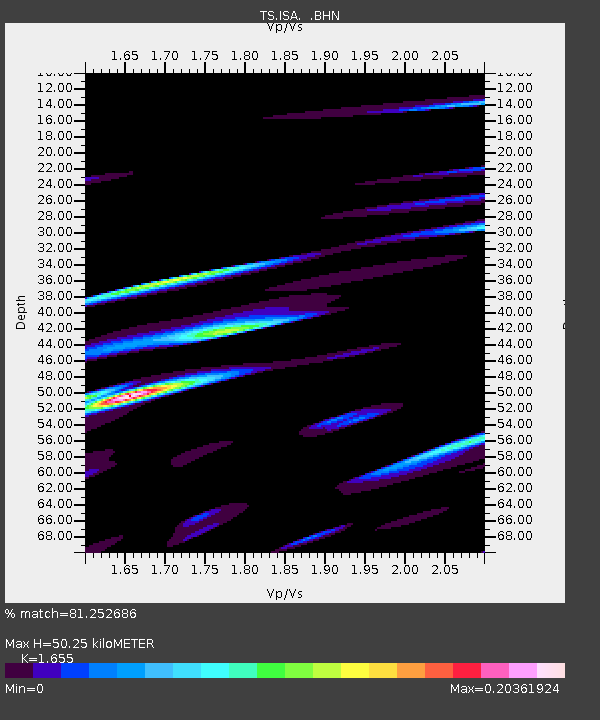
| Estimated Moho Depth: |
50.25 km |
| Estimated Crust Vp/Vs: |
1.65 |
| Assumed Crust Vp: |
6.1 km/s |
| Estimated Crust Vs: |
3.686 km/s |
| Estimated Crust Poisson's Ratio: |
0.21 |
|
| Radial Match: |
81.252686 % |
| Radial Bump: |
400 |
| Transverse Match: |
47.70577 % |
| Transverse Bump: |
400 |
| SOD ConfigId: |
17000 |
| Insert Time: |
2010-02-26 14:23:59.248 +0000 |
| GWidth: |
2.5 |
| Max Bumps: |
400 |
| Tol: |
0.001 |
|

Signal To Noise
| Channel | StoN | STA | LTA |
| TS:ISA: :BHN:19940418T21:50:27.704004Z | 0.59105754 | 9.137283E-8 | 1.5459212E-7 |
| TS:ISA: :BHE:19940418T21:50:27.704004Z | 1.333679 | 2.748807E-7 | 2.0610709E-7 |
| TS:ISA: :BHZ:19940418T21:50:27.706018Z | 5.4319034 | 7.080068E-7 | 1.303423E-7 |
| Arrivals |
| Ps | 5.5 SECOND |
| PpPs | 21 SECOND |
| PsPs/PpSs | 27 SECOND |


