You are here: Home > Network List > IU - Global Seismograph Network (GSN - IRIS/USGS) Stations List
> Station LSZ Lusaka, Zambia > Earthquake Result Viewer
LSZ Lusaka, Zambia - Earthquake Result Viewer
| Earthquake location: |
Sumbawa Region, Indonesia |
| Earthquake latitude/longitude: |
-9.1/118.6 |
| Earthquake time(UTC): |
2016/12/29 (364) 22:30:18 GMT |
| Earthquake Depth: |
72 km |
| Earthquake Magnitude: |
6.2 Mwp |
| Earthquake Catalog/Contributor: |
NEIC PDE/us |
|
| Network: |
IU Global Seismograph Network (GSN - IRIS/USGS) |
| Station: |
LSZ Lusaka, Zambia |
| Lat/Lon: |
15.28 S/28.19 E |
| Elevation: |
1200 m |
|
| Distance: |
88.1 deg |
| Az: |
254.937 deg |
| Baz: |
98.805 deg |
| Ray Param: |
0.042734444 |
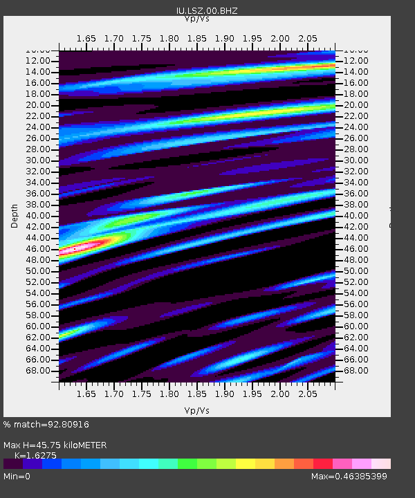
| Estimated Moho Depth: |
45.75 km |
| Estimated Crust Vp/Vs: |
1.63 |
| Assumed Crust Vp: |
6.642 km/s |
| Estimated Crust Vs: |
4.081 km/s |
| Estimated Crust Poisson's Ratio: |
0.20 |
|
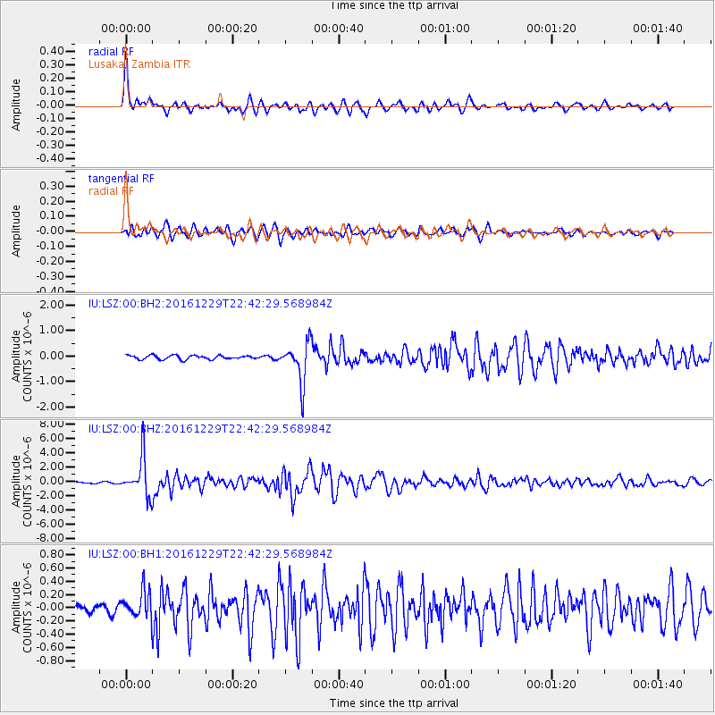
| Radial Match: |
92.80916 % |
| Radial Bump: |
400 |
| Transverse Match: |
86.97036 % |
| Transverse Bump: |
400 |
| SOD ConfigId: |
1943534 |
| Insert Time: |
2017-01-12 22:31:22.659 +0000 |
| GWidth: |
2.5 |
| Max Bumps: |
400 |
| Tol: |
0.001 |
|
Signal To Noise
| Channel | StoN | STA | LTA |
| IU:LSZ:00:BHZ:20161229T22:42:29.568984Z | 29.469688 | 2.6970338E-6 | 9.151891E-8 |
| IU:LSZ:00:BH1:20161229T22:42:29.568984Z | 2.2792237 | 2.0267505E-7 | 8.8922846E-8 |
| IU:LSZ:00:BH2:20161229T22:42:29.568984Z | 10.239069 | 7.8716215E-7 | 7.687829E-8 |
| Arrivals |
| Ps | 4.4 SECOND |
| PpPs | 18 SECOND |
| PsPs/PpSs | 22 SECOND |


