You are here: Home > Network List > TA - USArray Transportable Network (new EarthScope stations) Stations List
> Station F09A S2 Ranch, Elgin, OR, USA > Earthquake Result Viewer
F09A S2 Ranch, Elgin, OR, USA - Earthquake Result Viewer
| Earthquake location: |
Santa Cruz Islands |
| Earthquake latitude/longitude: |
-11.6/165.8 |
| Earthquake time(UTC): |
2007/09/02 (245) 01:05:18 GMT |
| Earthquake Depth: |
35 km |
| Earthquake Magnitude: |
5.9 MB, 7.3 MS, 7.2 MW, 6.9 ME |
| Earthquake Catalog/Contributor: |
WHDF/NEIC |
|
| Network: |
TA USArray Transportable Network (new EarthScope stations) |
| Station: |
F09A S2 Ranch, Elgin, OR, USA |
| Lat/Lon: |
45.71 N/117.91 W |
| Elevation: |
894 m |
|
| Distance: |
88.9 deg |
| Az: |
42.921 deg |
| Baz: |
252.218 deg |
| Ray Param: |
0.042214636 |
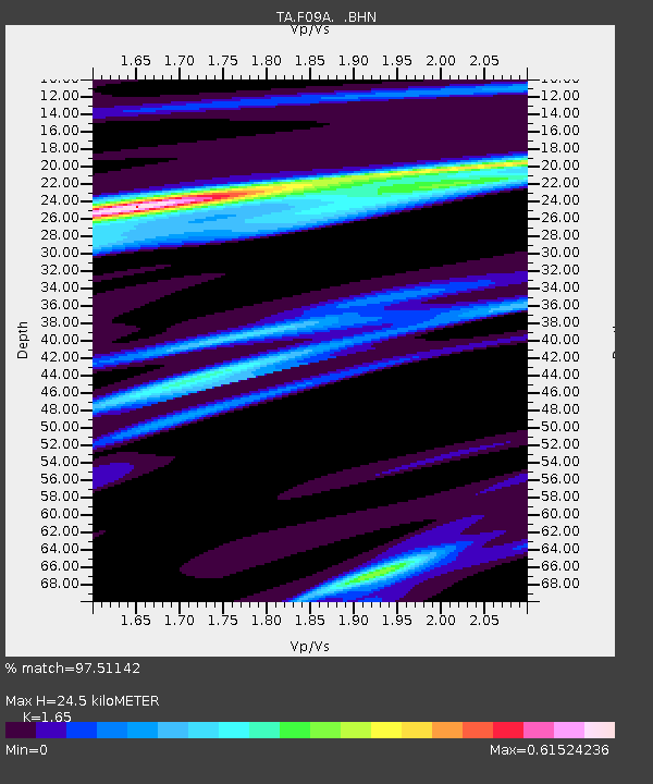
| Estimated Moho Depth: |
24.5 km |
| Estimated Crust Vp/Vs: |
1.65 |
| Assumed Crust Vp: |
6.571 km/s |
| Estimated Crust Vs: |
3.982 km/s |
| Estimated Crust Poisson's Ratio: |
0.21 |
|
| Radial Match: |
97.51142 % |
| Radial Bump: |
235 |
| Transverse Match: |
92.794266 % |
| Transverse Bump: |
400 |
| SOD ConfigId: |
2564 |
| Insert Time: |
2010-03-07 02:57:01.898 +0000 |
| GWidth: |
2.5 |
| Max Bumps: |
400 |
| Tol: |
0.001 |
|
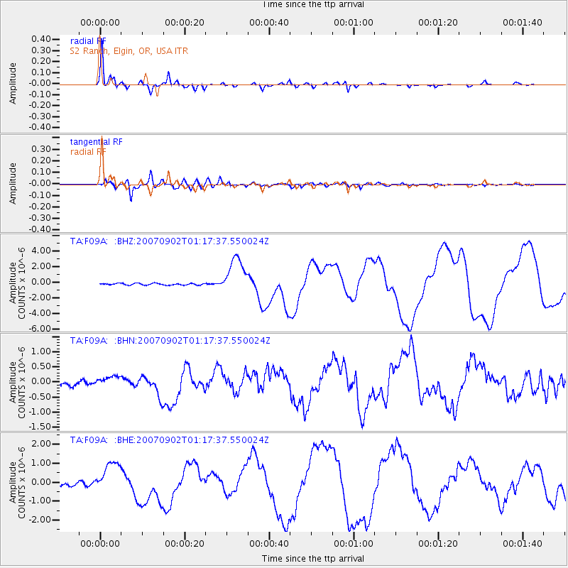
Signal To Noise
| Channel | StoN | STA | LTA |
| TA:F09A: :BHN:20070902T01:17:37.550024Z | 2.3418908 | 1.8093249E-7 | 7.7259145E-8 |
| TA:F09A: :BHE:20070902T01:17:37.550024Z | 7.2090077 | 8.452532E-7 | 1.1724959E-7 |
| TA:F09A: :BHZ:20070902T01:17:37.550024Z | 22.543217 | 2.413983E-6 | 1.07082464E-7 |
| Arrivals |
| Ps | 2.5 SECOND |
| PpPs | 9.6 SECOND |
| PsPs/PpSs | 12 SECOND |


