You are here: Home > Network List > TA - USArray Transportable Network (new EarthScope stations) Stations List
> Station F09A S2 Ranch, Elgin, OR, USA > Earthquake Result Viewer
F09A S2 Ranch, Elgin, OR, USA - Earthquake Result Viewer
| Earthquake location: |
Vanuatu Islands |
| Earthquake latitude/longitude: |
-15.6/167.7 |
| Earthquake time(UTC): |
2007/08/01 (213) 17:08:51 GMT |
| Earthquake Depth: |
120 km |
| Earthquake Magnitude: |
6.2 MB, 7.2 MW, 7.2 MW |
| Earthquake Catalog/Contributor: |
WHDF/NEIC |
|
| Network: |
TA USArray Transportable Network (new EarthScope stations) |
| Station: |
F09A S2 Ranch, Elgin, OR, USA |
| Lat/Lon: |
45.71 N/117.91 W |
| Elevation: |
894 m |
|
| Distance: |
90.5 deg |
| Az: |
42.451 deg |
| Baz: |
248.162 deg |
| Ray Param: |
0.04164301 |
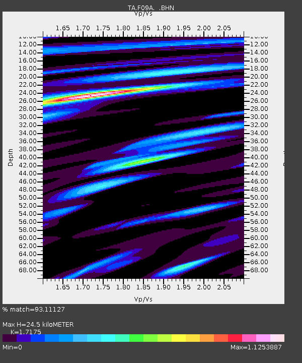
| Estimated Moho Depth: |
24.5 km |
| Estimated Crust Vp/Vs: |
1.72 |
| Assumed Crust Vp: |
6.571 km/s |
| Estimated Crust Vs: |
3.826 km/s |
| Estimated Crust Poisson's Ratio: |
0.24 |
|
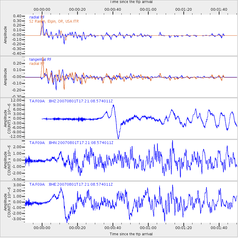
| Radial Match: |
93.11127 % |
| Radial Bump: |
400 |
| Transverse Match: |
87.82056 % |
| Transverse Bump: |
400 |
| SOD ConfigId: |
2564 |
| Insert Time: |
2010-03-07 02:57:10.151 +0000 |
| GWidth: |
2.5 |
| Max Bumps: |
400 |
| Tol: |
0.001 |
|
Signal To Noise
| Channel | StoN | STA | LTA |
| TA:F09A: :BHN:20070801T17:21:08.574011Z | 0.66187227 | 1.09922865E-7 | 1.6607868E-7 |
| TA:F09A: :BHE:20070801T17:21:08.574011Z | 1.1753129 | 1.9979035E-7 | 1.6998908E-7 |
| TA:F09A: :BHZ:20070801T17:21:08.574011Z | 2.0274465 | 7.5052293E-7 | 3.7018134E-7 |
| Arrivals |
| Ps | 2.7 SECOND |
| PpPs | 9.9 SECOND |
| PsPs/PpSs | 13 SECOND |


