You are here: Home > Network List > TA - USArray Transportable Network (new EarthScope stations) Stations List
> Station G18K Tagagawik, AK, USA > Earthquake Result Viewer
G18K Tagagawik, AK, USA - Earthquake Result Viewer
| Earthquake location: |
Vanuatu Islands |
| Earthquake latitude/longitude: |
-18.0/168.6 |
| Earthquake time(UTC): |
2019/08/06 (218) 22:14:14 GMT |
| Earthquake Depth: |
150 km |
| Earthquake Magnitude: |
5.9 Mww |
| Earthquake Catalog/Contributor: |
NEIC PDE/us |
|
| Network: |
TA USArray Transportable Network (new EarthScope stations) |
| Station: |
G18K Tagagawik, AK, USA |
| Lat/Lon: |
65.89 N/158.65 W |
| Elevation: |
484 m |
|
| Distance: |
87.2 deg |
| Az: |
12.84 deg |
| Baz: |
210.995 deg |
| Ray Param: |
0.043169305 |
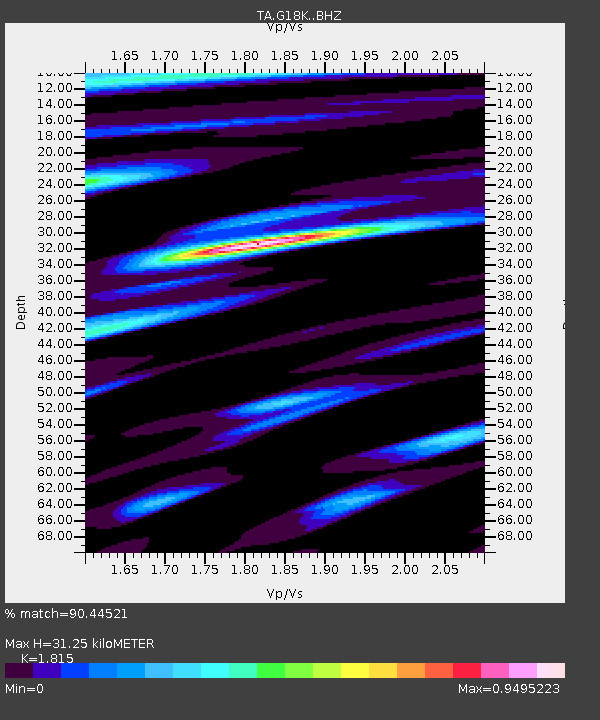
| Estimated Moho Depth: |
31.25 km |
| Estimated Crust Vp/Vs: |
1.82 |
| Assumed Crust Vp: |
6.1 km/s |
| Estimated Crust Vs: |
3.361 km/s |
| Estimated Crust Poisson's Ratio: |
0.28 |
|
| Radial Match: |
90.44521 % |
| Radial Bump: |
400 |
| Transverse Match: |
85.01441 % |
| Transverse Bump: |
400 |
| SOD ConfigId: |
19053131 |
| Insert Time: |
2019-08-20 22:21:38.621 +0000 |
| GWidth: |
2.5 |
| Max Bumps: |
400 |
| Tol: |
0.001 |
|

Signal To Noise
| Channel | StoN | STA | LTA |
| TA:G18K: :BHZ:20190806T22:26:12.675004Z | 16.19879 | 9.098338E-7 | 5.616678E-8 |
| TA:G18K: :BHN:20190806T22:26:12.675004Z | 6.4094005 | 2.2490232E-7 | 3.508945E-8 |
| TA:G18K: :BHE:20190806T22:26:12.675004Z | 4.156387 | 1.6956248E-7 | 4.0795644E-8 |
| Arrivals |
| Ps | 4.3 SECOND |
| PpPs | 14 SECOND |
| PsPs/PpSs | 18 SECOND |


