You are here: Home > Network List > TA - USArray Transportable Network (new EarthScope stations) Stations List
> Station H23K Yukon River, AK, USA > Earthquake Result Viewer
H23K Yukon River, AK, USA - Earthquake Result Viewer
| Earthquake location: |
Vanuatu Islands |
| Earthquake latitude/longitude: |
-18.0/168.6 |
| Earthquake time(UTC): |
2019/08/06 (218) 22:14:14 GMT |
| Earthquake Depth: |
150 km |
| Earthquake Magnitude: |
5.9 Mww |
| Earthquake Catalog/Contributor: |
NEIC PDE/us |
|
| Network: |
TA USArray Transportable Network (new EarthScope stations) |
| Station: |
H23K Yukon River, AK, USA |
| Lat/Lon: |
65.83 N/149.54 W |
| Elevation: |
617 m |
|
| Distance: |
89.3 deg |
| Az: |
15.941 deg |
| Baz: |
219.398 deg |
| Ray Param: |
0.041723307 |
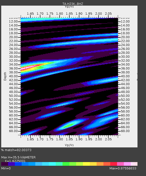
| Estimated Moho Depth: |
35.5 km |
| Estimated Crust Vp/Vs: |
1.62 |
| Assumed Crust Vp: |
6.566 km/s |
| Estimated Crust Vs: |
4.047 km/s |
| Estimated Crust Poisson's Ratio: |
0.19 |
|
| Radial Match: |
82.00373 % |
| Radial Bump: |
400 |
| Transverse Match: |
67.16886 % |
| Transverse Bump: |
400 |
| SOD ConfigId: |
19053131 |
| Insert Time: |
2019-08-20 22:21:48.621 +0000 |
| GWidth: |
2.5 |
| Max Bumps: |
400 |
| Tol: |
0.001 |
|

Signal To Noise
| Channel | StoN | STA | LTA |
| TA:H23K: :BHZ:20190806T22:26:22.550004Z | 10.007304 | 4.2592265E-7 | 4.2561176E-8 |
| TA:H23K: :BHN:20190806T22:26:22.550004Z | 5.6409698 | 1.3730063E-7 | 2.4339899E-8 |
| TA:H23K: :BHE:20190806T22:26:22.550004Z | 2.242814 | 6.675414E-8 | 2.9763566E-8 |
| Arrivals |
| Ps | 3.4 SECOND |
| PpPs | 14 SECOND |
| PsPs/PpSs | 17 SECOND |


