You are here: Home > Network List > TA - USArray Transportable Network (new EarthScope stations) Stations List
> Station I17K Unalakleet, AK, USA > Earthquake Result Viewer
I17K Unalakleet, AK, USA - Earthquake Result Viewer
| Earthquake location: |
Vanuatu Islands |
| Earthquake latitude/longitude: |
-18.0/168.6 |
| Earthquake time(UTC): |
2019/08/06 (218) 22:14:14 GMT |
| Earthquake Depth: |
150 km |
| Earthquake Magnitude: |
5.9 Mww |
| Earthquake Catalog/Contributor: |
NEIC PDE/us |
|
| Network: |
TA USArray Transportable Network (new EarthScope stations) |
| Station: |
I17K Unalakleet, AK, USA |
| Lat/Lon: |
63.89 N/160.70 W |
| Elevation: |
105 m |
|
| Distance: |
85.0 deg |
| Az: |
13.098 deg |
| Baz: |
209.167 deg |
| Ray Param: |
0.044726122 |
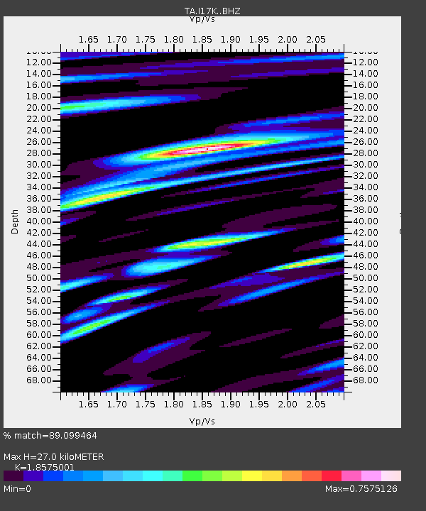
| Estimated Moho Depth: |
27.0 km |
| Estimated Crust Vp/Vs: |
1.86 |
| Assumed Crust Vp: |
6.276 km/s |
| Estimated Crust Vs: |
3.379 km/s |
| Estimated Crust Poisson's Ratio: |
0.30 |
|
| Radial Match: |
89.099464 % |
| Radial Bump: |
400 |
| Transverse Match: |
87.25775 % |
| Transverse Bump: |
400 |
| SOD ConfigId: |
19053131 |
| Insert Time: |
2019-08-20 22:21:52.106 +0000 |
| GWidth: |
2.5 |
| Max Bumps: |
400 |
| Tol: |
0.001 |
|
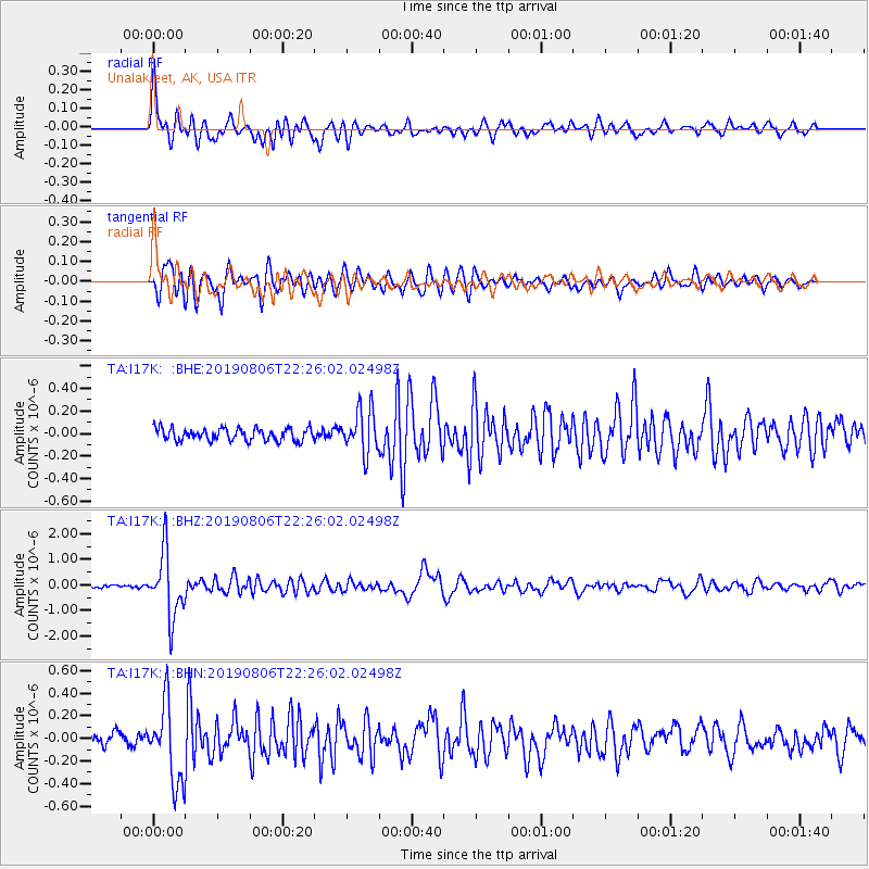
Signal To Noise
| Channel | StoN | STA | LTA |
| TA:I17K: :BHZ:20190806T22:26:02.02498Z | 18.907194 | 1.2464926E-6 | 6.59269E-8 |
| TA:I17K: :BHN:20190806T22:26:02.02498Z | 6.5421157 | 3.4687304E-7 | 5.302154E-8 |
| TA:I17K: :BHE:20190806T22:26:02.02498Z | 3.5330777 | 1.9273932E-7 | 5.455281E-8 |
| Arrivals |
| Ps | 3.8 SECOND |
| PpPs | 12 SECOND |
| PsPs/PpSs | 16 SECOND |


