You are here: Home > Network List > TA - USArray Transportable Network (new EarthScope stations) Stations List
> Station J18K Innoko River, AK, USA > Earthquake Result Viewer
J18K Innoko River, AK, USA - Earthquake Result Viewer
| Earthquake location: |
Vanuatu Islands |
| Earthquake latitude/longitude: |
-18.0/168.6 |
| Earthquake time(UTC): |
2019/08/06 (218) 22:14:14 GMT |
| Earthquake Depth: |
150 km |
| Earthquake Magnitude: |
5.9 Mww |
| Earthquake Catalog/Contributor: |
NEIC PDE/us |
|
| Network: |
TA USArray Transportable Network (new EarthScope stations) |
| Station: |
J18K Innoko River, AK, USA |
| Lat/Lon: |
63.47 N/156.72 W |
| Elevation: |
506 m |
|
| Distance: |
85.6 deg |
| Az: |
14.842 deg |
| Baz: |
212.872 deg |
| Ray Param: |
0.044335596 |
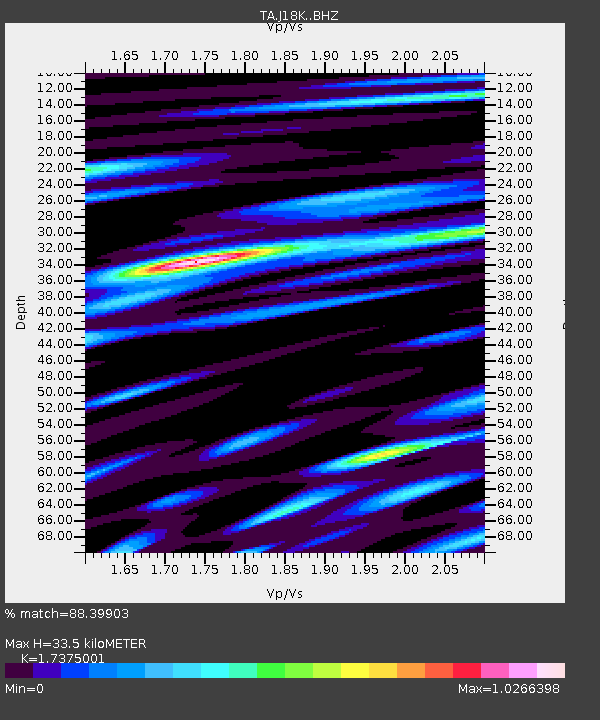
| Estimated Moho Depth: |
33.5 km |
| Estimated Crust Vp/Vs: |
1.74 |
| Assumed Crust Vp: |
6.182 km/s |
| Estimated Crust Vs: |
3.558 km/s |
| Estimated Crust Poisson's Ratio: |
0.25 |
|
| Radial Match: |
88.39903 % |
| Radial Bump: |
400 |
| Transverse Match: |
78.09652 % |
| Transverse Bump: |
390 |
| SOD ConfigId: |
19053131 |
| Insert Time: |
2019-08-20 22:21:57.950 +0000 |
| GWidth: |
2.5 |
| Max Bumps: |
400 |
| Tol: |
0.001 |
|

Signal To Noise
| Channel | StoN | STA | LTA |
| TA:J18K: :BHZ:20190806T22:26:04.750017Z | 27.62136 | 1.109462E-6 | 4.0166814E-8 |
| TA:J18K: :BHN:20190806T22:26:04.750017Z | 8.342588 | 3.7780552E-7 | 4.5286367E-8 |
| TA:J18K: :BHE:20190806T22:26:04.750017Z | 8.907762 | 2.908543E-7 | 3.2651783E-8 |
| Arrivals |
| Ps | 4.1 SECOND |
| PpPs | 15 SECOND |
| PsPs/PpSs | 19 SECOND |


