You are here: Home > Network List > TA - USArray Transportable Network (new EarthScope stations) Stations List
> Station F09A S2 Ranch, Elgin, OR, USA > Earthquake Result Viewer
F09A S2 Ranch, Elgin, OR, USA - Earthquake Result Viewer

| Earthquake location: |
Kamchatka Peninsula, Russia |
| Earthquake latitude/longitude: |
52.1/157.3 |
| Earthquake time(UTC): |
2007/05/30 (150) 20:22:12 GMT |
| Earthquake Depth: |
116 km |
| Earthquake Magnitude: |
6.4 MB, 6.4 MW, 6.4 MW |
| Earthquake Catalog/Contributor: |
WHDF/NEIC |
|
| Network: |
TA USArray Transportable Network (new EarthScope stations) |
| Station: |
F09A S2 Ranch, Elgin, OR, USA |
| Lat/Lon: |
45.71 N/117.91 W |
| Elevation: |
894 m |
|
| Distance: |
53.1 deg |
| Az: |
60.819 deg |
| Baz: |
309.828 deg |
| Ray Param: |
0.06597061 |
| Estimated Moho Depth: |
56.75 km |
| Estimated Crust Vp/Vs: |
1.88 |
| Assumed Crust Vp: |
6.571 km/s |
| Estimated Crust Vs: |
3.495 km/s |
| Estimated Crust Poisson's Ratio: |
0.30 |
|
| Radial Match: |
89.502846 % |
| Radial Bump: |
400 |
| Transverse Match: |
75.85051 % |
| Transverse Bump: |
400 |
| SOD ConfigId: |
2564 |
| Insert Time: |
2010-03-07 02:57:41.031 +0000 |
| GWidth: |
2.5 |
| Max Bumps: |
400 |
| Tol: |
0.001 |
|
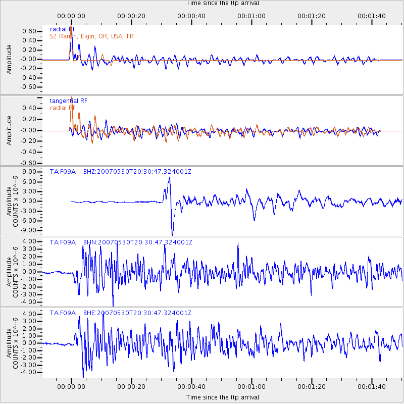
Signal To Noise
| Channel | StoN | STA | LTA |
| TA:F09A: :BHN:20070530T20:30:47.324001Z | 18.743328 | 1.3732958E-6 | 7.326852E-8 |
| TA:F09A: :BHE:20070530T20:30:47.324001Z | 16.472015 | 1.7120288E-6 | 1.03935605E-7 |
| TA:F09A: :BHZ:20070530T20:30:47.324001Z | 40.06217 | 4.5895463E-6 | 1.14560606E-7 |
| Arrivals |
| Ps | 8.0 SECOND |
| PpPs | 24 SECOND |
| PsPs/PpSs | 32 SECOND |


