You are here: Home > Network List > TA - USArray Transportable Network (new EarthScope stations) Stations List
> Station F09A S2 Ranch, Elgin, OR, USA > Earthquake Result Viewer
F09A S2 Ranch, Elgin, OR, USA - Earthquake Result Viewer

| Earthquake location: |
Northern Mid-Atlantic Ridge |
| Earthquake latitude/longitude: |
52.4/-31.8 |
| Earthquake time(UTC): |
2007/05/23 (143) 04:41:46 GMT |
| Earthquake Depth: |
10 km |
| Earthquake Magnitude: |
5.6 MS, 5.4 MB, 5.7 MW, 5.6 MW |
| Earthquake Catalog/Contributor: |
WHDF/NEIC |
|
| Network: |
TA USArray Transportable Network (new EarthScope stations) |
| Station: |
F09A S2 Ranch, Elgin, OR, USA |
| Lat/Lon: |
45.71 N/117.91 W |
| Elevation: |
894 m |
|
| Distance: |
53.6 deg |
| Az: |
299.773 deg |
| Baz: |
49.449 deg |
| Ray Param: |
0.06595907 |
| Estimated Moho Depth: |
35.75 km |
| Estimated Crust Vp/Vs: |
1.97 |
| Assumed Crust Vp: |
6.571 km/s |
| Estimated Crust Vs: |
3.331 km/s |
| Estimated Crust Poisson's Ratio: |
0.33 |
|
| Radial Match: |
85.27539 % |
| Radial Bump: |
400 |
| Transverse Match: |
85.14183 % |
| Transverse Bump: |
400 |
| SOD ConfigId: |
2564 |
| Insert Time: |
2010-03-07 02:57:43.336 +0000 |
| GWidth: |
2.5 |
| Max Bumps: |
400 |
| Tol: |
0.001 |
|
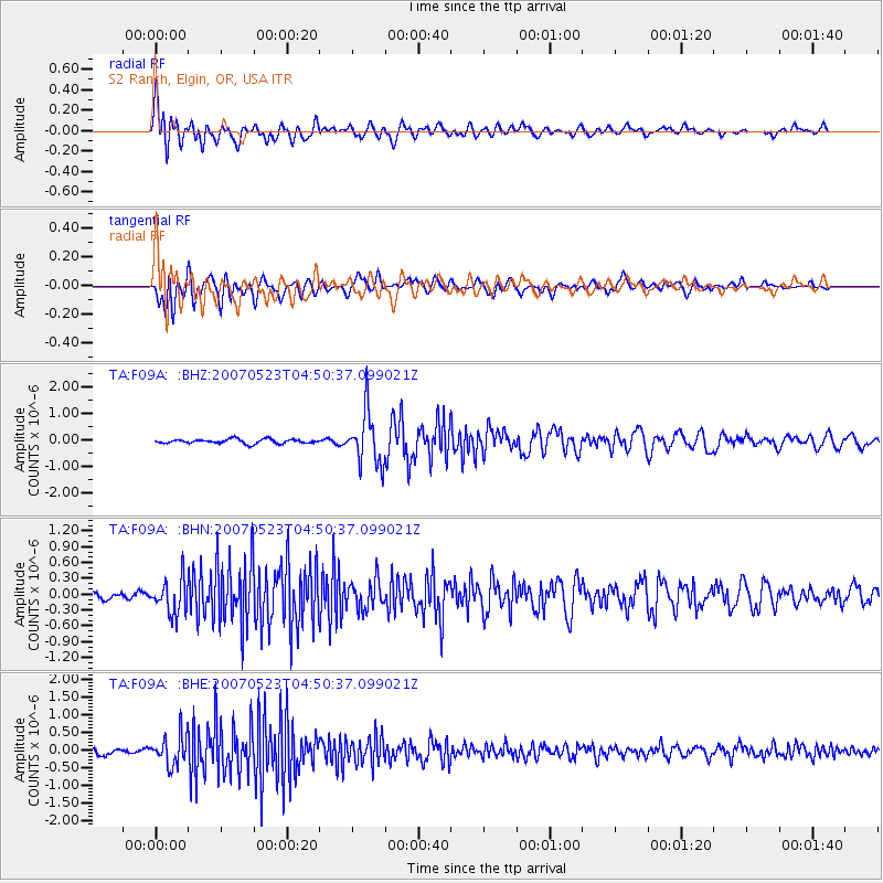
Signal To Noise
| Channel | StoN | STA | LTA |
| TA:F09A: :BHN:20070523T04:50:37.099021Z | 4.736525 | 3.2660105E-7 | 6.8953725E-8 |
| TA:F09A: :BHE:20070523T04:50:37.099021Z | 5.0133004 | 4.229743E-7 | 8.437043E-8 |
| TA:F09A: :BHZ:20070523T04:50:37.099021Z | 11.867161 | 9.738004E-7 | 8.205842E-8 |
| Arrivals |
| Ps | 5.6 SECOND |
| PpPs | 15 SECOND |
| PsPs/PpSs | 21 SECOND |


