You are here: Home > Network List > TA - USArray Transportable Network (new EarthScope stations) Stations List
> Station F09A S2 Ranch, Elgin, OR, USA > Earthquake Result Viewer
F09A S2 Ranch, Elgin, OR, USA - Earthquake Result Viewer
| Earthquake location: |
Solomon Islands |
| Earthquake latitude/longitude: |
-7.3/155.7 |
| Earthquake time(UTC): |
2007/04/01 (091) 21:11:33 GMT |
| Earthquake Depth: |
10 km |
| Earthquake Magnitude: |
6.3 MB |
| Earthquake Catalog/Contributor: |
WHDF/NEIC |
|
| Network: |
TA USArray Transportable Network (new EarthScope stations) |
| Station: |
F09A S2 Ranch, Elgin, OR, USA |
| Lat/Lon: |
45.71 N/117.91 W |
| Elevation: |
894 m |
|
| Distance: |
92.6 deg |
| Az: |
44.429 deg |
| Baz: |
262.315 deg |
| Ray Param: |
0.04142063 |
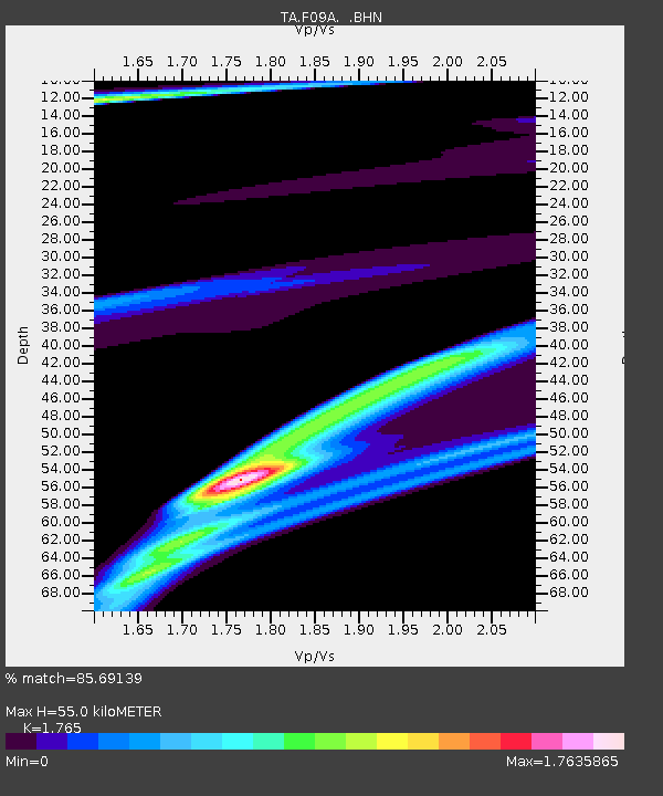
| Estimated Moho Depth: |
55.0 km |
| Estimated Crust Vp/Vs: |
1.76 |
| Assumed Crust Vp: |
6.571 km/s |
| Estimated Crust Vs: |
3.723 km/s |
| Estimated Crust Poisson's Ratio: |
0.26 |
|
| Radial Match: |
85.69139 % |
| Radial Bump: |
400 |
| Transverse Match: |
66.78058 % |
| Transverse Bump: |
400 |
| SOD ConfigId: |
2564 |
| Insert Time: |
2010-03-07 02:57:45.432 +0000 |
| GWidth: |
2.5 |
| Max Bumps: |
400 |
| Tol: |
0.001 |
|
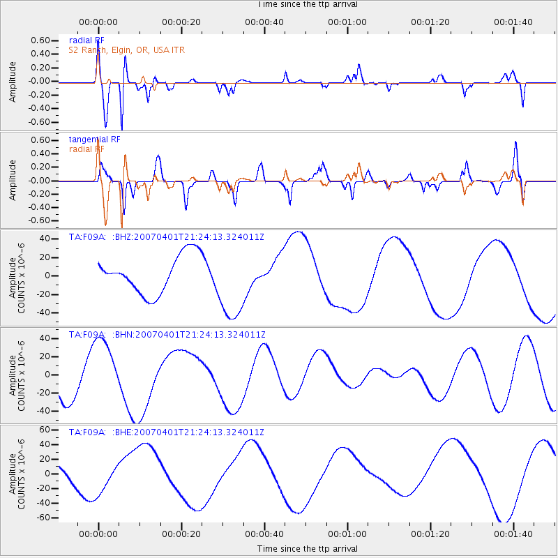
Signal To Noise
| Channel | StoN | STA | LTA |
| TA:F09A: :BHN:20070401T21:24:13.324011Z | 1.45461 | 3.3673034E-5 | 2.3149183E-5 |
| TA:F09A: :BHE:20070401T21:24:13.324011Z | 1.9085846 | 2.2540687E-5 | 1.1810159E-5 |
| TA:F09A: :BHZ:20070401T21:24:13.324011Z | 2.0410933 | 4.155016E-5 | 2.0356816E-5 |
| Arrivals |
| Ps | 6.5 SECOND |
| PpPs | 23 SECOND |
| PsPs/PpSs | 29 SECOND |


