You are here: Home > Network List > TA - USArray Transportable Network (new EarthScope stations) Stations List
> Station F09A S2 Ranch, Elgin, OR, USA > Earthquake Result Viewer
F09A S2 Ranch, Elgin, OR, USA - Earthquake Result Viewer

| Earthquake location: |
Loyalty Islands |
| Earthquake latitude/longitude: |
-20.1/168.9 |
| Earthquake time(UTC): |
2008/04/09 (100) 12:46:12 GMT |
| Earthquake Depth: |
33 km |
| Earthquake Magnitude: |
6.3 MB, 7.3 MS, 7.3 MW, 7.3 MW |
| Earthquake Catalog/Contributor: |
WHDF/NEIC |
|
| Network: |
TA USArray Transportable Network (new EarthScope stations) |
| Station: |
F09A S2 Ranch, Elgin, OR, USA |
| Lat/Lon: |
45.71 N/117.91 W |
| Elevation: |
894 m |
|
| Distance: |
93.0 deg |
| Az: |
42.201 deg |
| Baz: |
244.309 deg |
| Ray Param: |
0.041328825 |
| Estimated Moho Depth: |
25.75 km |
| Estimated Crust Vp/Vs: |
1.61 |
| Assumed Crust Vp: |
6.571 km/s |
| Estimated Crust Vs: |
4.081 km/s |
| Estimated Crust Poisson's Ratio: |
0.19 |
|
| Radial Match: |
85.36276 % |
| Radial Bump: |
308 |
| Transverse Match: |
89.433 % |
| Transverse Bump: |
400 |
| SOD ConfigId: |
2504 |
| Insert Time: |
2010-03-07 02:57:55.572 +0000 |
| GWidth: |
2.5 |
| Max Bumps: |
400 |
| Tol: |
0.001 |
|
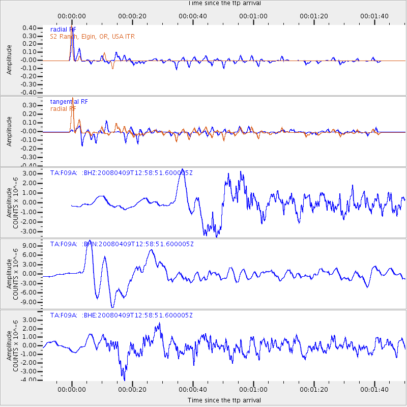
Signal To Noise
| Channel | StoN | STA | LTA |
| TA:F09A: :BHN:20080409T12:58:51.600005Z | 5.373015 | 2.1208061E-6 | 3.9471433E-7 |
| TA:F09A: :BHE:20080409T12:58:51.600005Z | 1.0599941 | 4.2426308E-7 | 4.0025043E-7 |
| TA:F09A: :BHZ:20080409T12:58:51.600005Z | 1.0191797 | 4.0138517E-7 | 3.938316E-7 |
| Arrivals |
| Ps | 2.4 SECOND |
| PpPs | 10.0 SECOND |
| PsPs/PpSs | 12 SECOND |


