You are here: Home > Network List > TA - USArray Transportable Network (new EarthScope stations) Stations List
> Station F09A S2 Ranch, Elgin, OR, USA > Earthquake Result Viewer
F09A S2 Ranch, Elgin, OR, USA - Earthquake Result Viewer
| Earthquake location: |
Andreanof Islands, Aleutian Is. |
| Earthquake latitude/longitude: |
51.9/-179.4 |
| Earthquake time(UTC): |
2008/04/15 (106) 22:59:51 GMT |
| Earthquake Depth: |
10 km |
| Earthquake Magnitude: |
6.1 MB, 6.4 MS, 6.4 MW, 6.4 MW |
| Earthquake Catalog/Contributor: |
WHDF/NEIC |
|
| Network: |
TA USArray Transportable Network (new EarthScope stations) |
| Station: |
F09A S2 Ranch, Elgin, OR, USA |
| Lat/Lon: |
45.71 N/117.91 W |
| Elevation: |
894 m |
|
| Distance: |
39.9 deg |
| Az: |
73.715 deg |
| Baz: |
301.827 deg |
| Ray Param: |
0.074722685 |
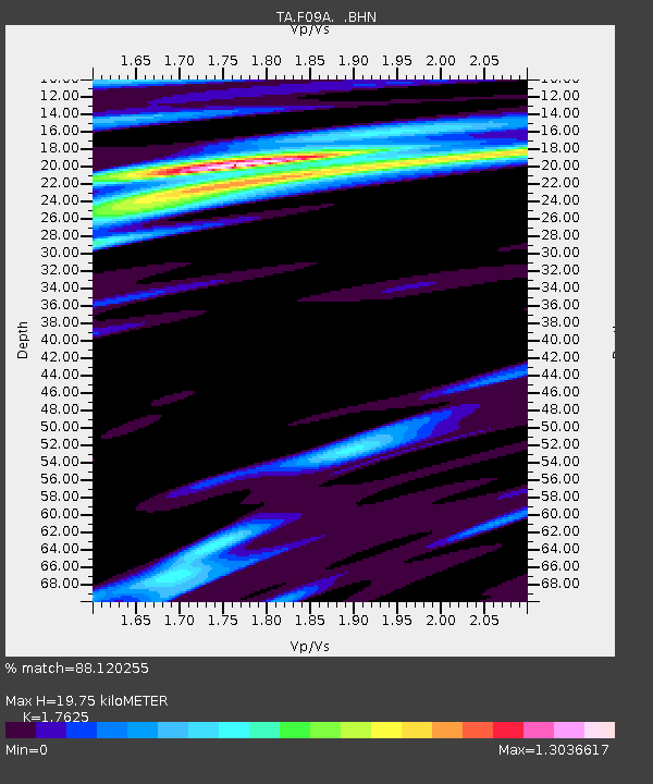
| Estimated Moho Depth: |
19.75 km |
| Estimated Crust Vp/Vs: |
1.76 |
| Assumed Crust Vp: |
6.571 km/s |
| Estimated Crust Vs: |
3.728 km/s |
| Estimated Crust Poisson's Ratio: |
0.26 |
|
| Radial Match: |
88.120255 % |
| Radial Bump: |
400 |
| Transverse Match: |
75.76747 % |
| Transverse Bump: |
400 |
| SOD ConfigId: |
2504 |
| Insert Time: |
2010-03-07 02:57:58.577 +0000 |
| GWidth: |
2.5 |
| Max Bumps: |
400 |
| Tol: |
0.001 |
|

Signal To Noise
| Channel | StoN | STA | LTA |
| TA:F09A: :BHN:20080415T23:06:54.350Z | 7.1695647 | 1.2955187E-6 | 1.8069699E-7 |
| TA:F09A: :BHE:20080415T23:06:54.350Z | 1.4235424 | 3.7338194E-7 | 2.622907E-7 |
| TA:F09A: :BHZ:20080415T23:06:54.350Z | 3.3646507 | 6.893932E-7 | 2.0489294E-7 |
| Arrivals |
| Ps | 2.5 SECOND |
| PpPs | 7.7 SECOND |
| PsPs/PpSs | 10 SECOND |


