You are here: Home > Network List > PF - Volcanologic Network of Piton de Fournaise-OVPF Stations List
> Station CIL Cilaos (Pompiers) > Earthquake Result Viewer
CIL Cilaos (Pompiers) - Earthquake Result Viewer
| Earthquake location: |
Sumbawa Region, Indonesia |
| Earthquake latitude/longitude: |
-9.1/118.6 |
| Earthquake time(UTC): |
2016/12/29 (364) 22:30:18 GMT |
| Earthquake Depth: |
72 km |
| Earthquake Magnitude: |
6.2 Mwp |
| Earthquake Catalog/Contributor: |
NEIC PDE/us |
|
| Network: |
PF Volcanologic Network of Piton de Fournaise-OVPF |
| Station: |
CIL Cilaos (Pompiers) |
| Lat/Lon: |
21.13 S/55.47 E |
| Elevation: |
1223 m |
|
| Distance: |
61.8 deg |
| Az: |
250.925 deg |
| Baz: |
89.102 deg |
| Ray Param: |
0.06046889 |
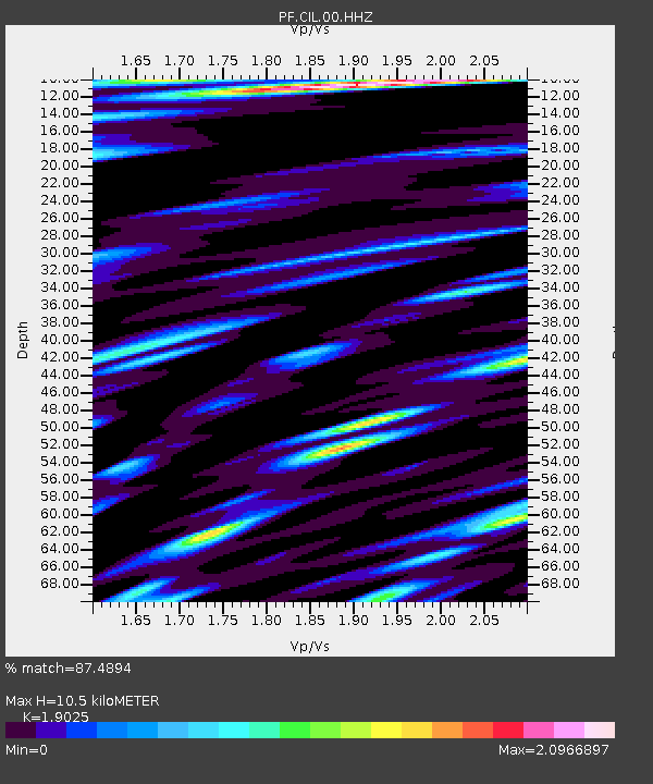
| Estimated Moho Depth: |
10.5 km |
| Estimated Crust Vp/Vs: |
1.90 |
| Assumed Crust Vp: |
4.73 km/s |
| Estimated Crust Vs: |
2.486 km/s |
| Estimated Crust Poisson's Ratio: |
0.31 |
|
| Radial Match: |
87.4894 % |
| Radial Bump: |
400 |
| Transverse Match: |
80.896 % |
| Transverse Bump: |
400 |
| SOD ConfigId: |
1943534 |
| Insert Time: |
2017-01-12 22:32:01.055 +0000 |
| GWidth: |
2.5 |
| Max Bumps: |
400 |
| Tol: |
0.001 |
|
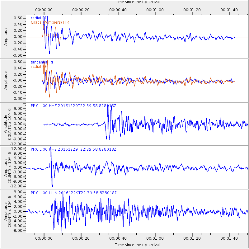
Signal To Noise
| Channel | StoN | STA | LTA |
| PF:CIL:00:HHZ:20161229T22:39:58.828018Z | 12.48119 | 5.406208E-6 | 4.3314841E-7 |
| PF:CIL:00:HHN:20161229T22:39:58.828018Z | 2.6882992 | 1.2849655E-6 | 4.7798454E-7 |
| PF:CIL:00:HHE:20161229T22:39:58.828018Z | 11.869623 | 3.9048227E-6 | 3.2897614E-7 |
| Arrivals |
| Ps | 2.0 SECOND |
| PpPs | 6.3 SECOND |
| PsPs/PpSs | 8.4 SECOND |


