You are here: Home > Network List > PF - Volcanologic Network of Piton de Fournaise-OVPF Stations List
> Station FLR Station Sismologique de Flanc Est > Earthquake Result Viewer
FLR Station Sismologique de Flanc Est - Earthquake Result Viewer
| Earthquake location: |
Sumbawa Region, Indonesia |
| Earthquake latitude/longitude: |
-9.1/118.6 |
| Earthquake time(UTC): |
2016/12/29 (364) 22:30:18 GMT |
| Earthquake Depth: |
72 km |
| Earthquake Magnitude: |
6.2 Mwp |
| Earthquake Catalog/Contributor: |
NEIC PDE/us |
|
| Network: |
PF Volcanologic Network of Piton de Fournaise-OVPF |
| Station: |
FLR Station Sismologique de Flanc Est |
| Lat/Lon: |
21.24 S/55.73 E |
| Elevation: |
1947 m |
|
| Distance: |
61.5 deg |
| Az: |
250.799 deg |
| Baz: |
88.948 deg |
| Ray Param: |
0.060625594 |
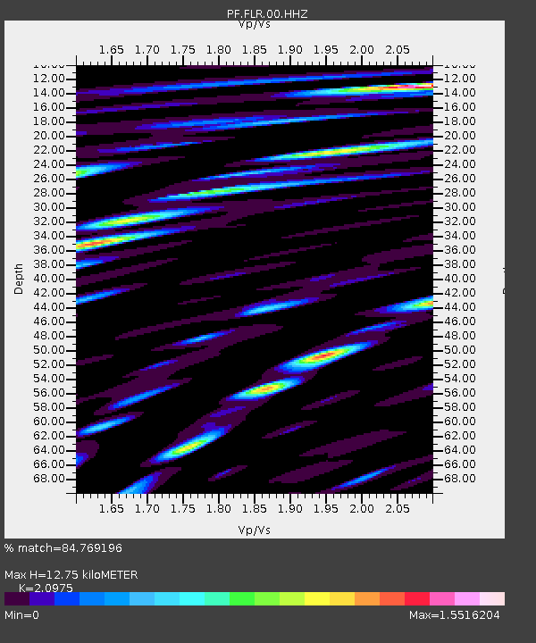
| Estimated Moho Depth: |
12.75 km |
| Estimated Crust Vp/Vs: |
2.10 |
| Assumed Crust Vp: |
4.73 km/s |
| Estimated Crust Vs: |
2.255 km/s |
| Estimated Crust Poisson's Ratio: |
0.35 |
|
| Radial Match: |
84.769196 % |
| Radial Bump: |
400 |
| Transverse Match: |
76.44022 % |
| Transverse Bump: |
400 |
| SOD ConfigId: |
1943534 |
| Insert Time: |
2017-01-12 22:32:03.911 +0000 |
| GWidth: |
2.5 |
| Max Bumps: |
400 |
| Tol: |
0.001 |
|
Signal To Noise
| Channel | StoN | STA | LTA |
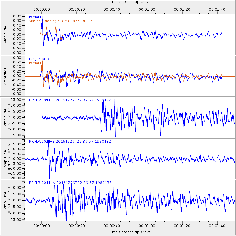
| PF:FLR:00:HHZ:20161229T22:39:57.198013Z | 12.294054 | 6.8579075E-6 | 5.578231E-7 |
| PF:FLR:00:HHN:20161229T22:39:57.198013Z | 0.71166265 | 9.91128E-7 | 1.3926935E-6 |
| PF:FLR:00:HHE:20161229T22:39:57.198013Z | 4.4416094 | 4.067479E-6 | 9.157669E-7 |
| Arrivals |
| Ps | 3.0 SECOND |
| PpPs | 8.2 SECOND |
| PsPs/PpSs | 11 SECOND |


