You are here: Home > Network List > PF - Volcanologic Network of Piton de Fournaise-OVPF Stations List
> Station FOR Station Sismologique de Chateau Fort > Earthquake Result Viewer
FOR Station Sismologique de Chateau Fort - Earthquake Result Viewer
| Earthquake location: |
Sumbawa Region, Indonesia |
| Earthquake latitude/longitude: |
-9.1/118.6 |
| Earthquake time(UTC): |
2016/12/29 (364) 22:30:18 GMT |
| Earthquake Depth: |
72 km |
| Earthquake Magnitude: |
6.2 Mwp |
| Earthquake Catalog/Contributor: |
NEIC PDE/us |
|
| Network: |
PF Volcanologic Network of Piton de Fournaise-OVPF |
| Station: |
FOR Station Sismologique de Chateau Fort |
| Lat/Lon: |
21.26 S/55.72 E |
| Elevation: |
2049 m |
|
| Distance: |
61.6 deg |
| Az: |
250.775 deg |
| Baz: |
88.942 deg |
| Ray Param: |
0.060617004 |
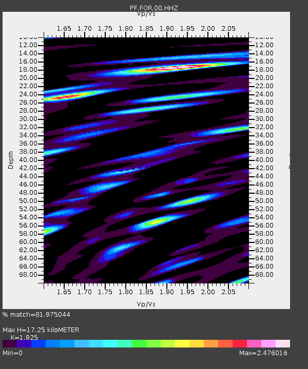
| Estimated Moho Depth: |
17.25 km |
| Estimated Crust Vp/Vs: |
1.92 |
| Assumed Crust Vp: |
4.73 km/s |
| Estimated Crust Vs: |
2.457 km/s |
| Estimated Crust Poisson's Ratio: |
0.32 |
|
| Radial Match: |
81.975044 % |
| Radial Bump: |
400 |
| Transverse Match: |
79.66504 % |
| Transverse Bump: |
400 |
| SOD ConfigId: |
1943534 |
| Insert Time: |
2017-01-12 22:32:04.110 +0000 |
| GWidth: |
2.5 |
| Max Bumps: |
400 |
| Tol: |
0.001 |
|
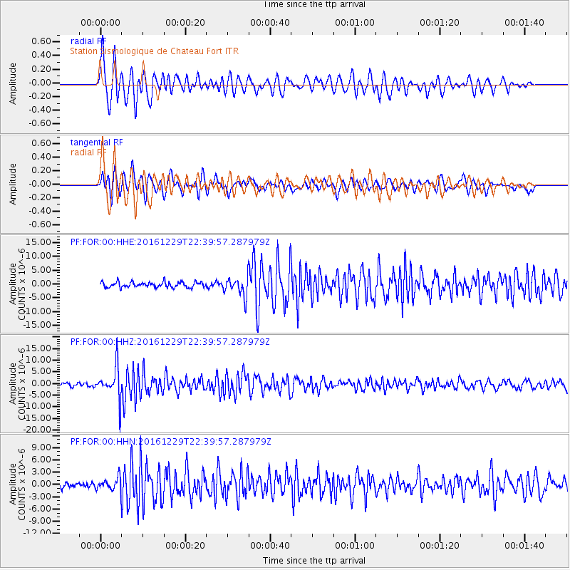
Signal To Noise
| Channel | StoN | STA | LTA |
| PF:FOR:00:HHZ:20161229T22:39:57.287979Z | 12.302894 | 6.9193934E-6 | 5.6242E-7 |
| PF:FOR:00:HHN:20161229T22:39:57.287979Z | 2.021059 | 1.4569036E-6 | 7.208616E-7 |
| PF:FOR:00:HHE:20161229T22:39:57.287979Z | 3.54995 | 3.415575E-6 | 9.621474E-7 |
| Arrivals |
| Ps | 3.4 SECOND |
| PpPs | 10 SECOND |
| PsPs/PpSs | 14 SECOND |


