You are here: Home > Network List > UW - Pacific Northwest Regional Seismic Network Stations List
> Station HOOD Mt Hood Meadows, OR CREST BB SMO > Earthquake Result Viewer
HOOD Mt Hood Meadows, OR CREST BB SMO - Earthquake Result Viewer
| Earthquake location: |
Vanuatu Islands |
| Earthquake latitude/longitude: |
-18.0/168.6 |
| Earthquake time(UTC): |
2019/08/06 (218) 22:14:14 GMT |
| Earthquake Depth: |
150 km |
| Earthquake Magnitude: |
5.9 Mww |
| Earthquake Catalog/Contributor: |
NEIC PDE/us |
|
| Network: |
UW Pacific Northwest Regional Seismic Network |
| Station: |
HOOD Mt Hood Meadows, OR CREST BB SMO |
| Lat/Lon: |
45.32 N/121.65 W |
| Elevation: |
1520 m |
|
| Distance: |
89.1 deg |
| Az: |
41.44 deg |
| Baz: |
243.225 deg |
| Ray Param: |
0.041753035 |
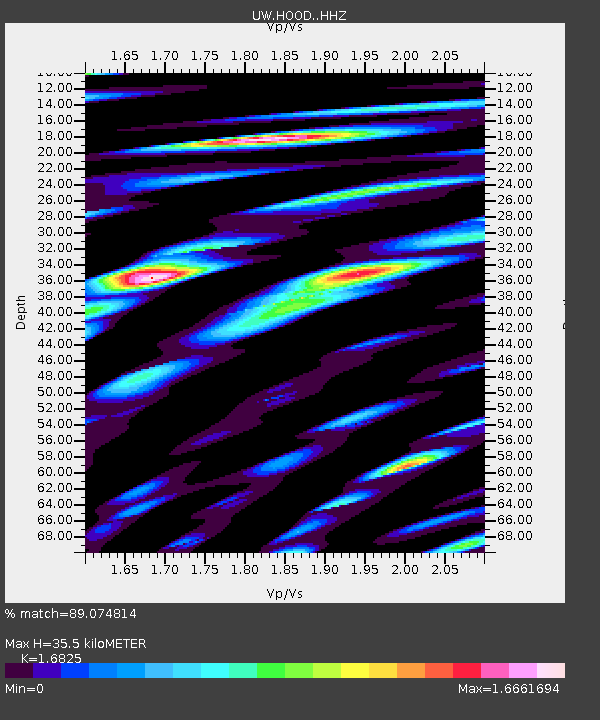
| Estimated Moho Depth: |
35.5 km |
| Estimated Crust Vp/Vs: |
1.68 |
| Assumed Crust Vp: |
6.597 km/s |
| Estimated Crust Vs: |
3.921 km/s |
| Estimated Crust Poisson's Ratio: |
0.23 |
|
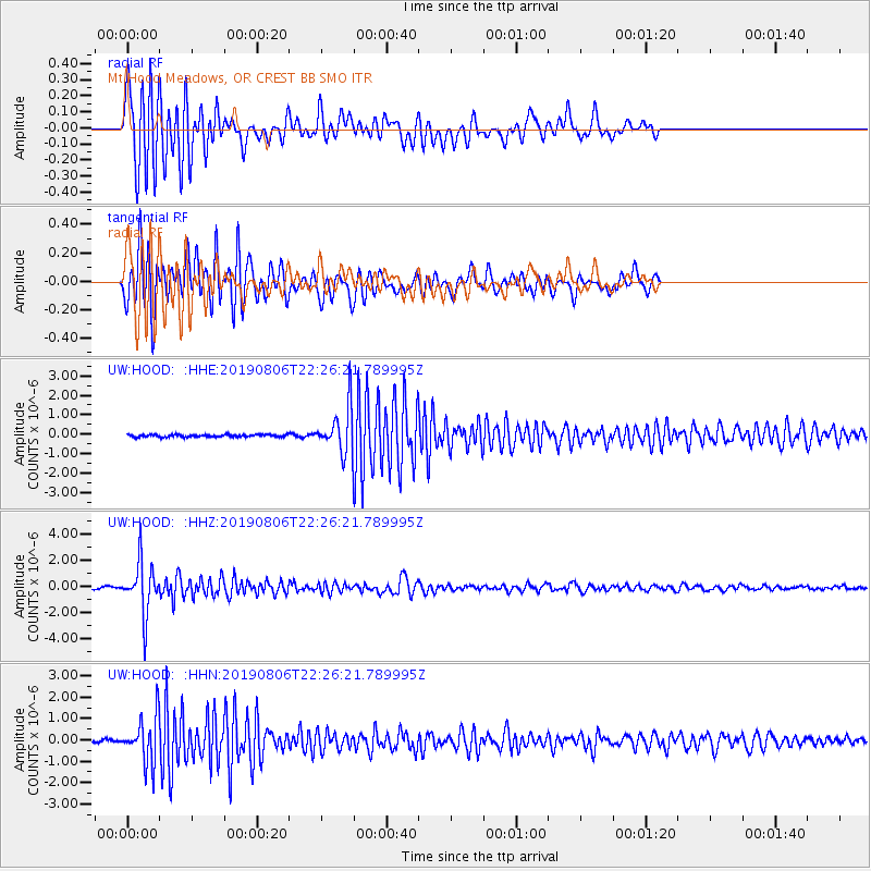
| Radial Match: |
89.074814 % |
| Radial Bump: |
400 |
| Transverse Match: |
86.4985 % |
| Transverse Bump: |
400 |
| SOD ConfigId: |
19053131 |
| Insert Time: |
2019-08-20 22:23:55.063 +0000 |
| GWidth: |
2.5 |
| Max Bumps: |
400 |
| Tol: |
0.001 |
|
Signal To Noise
| Channel | StoN | STA | LTA |
| UW:HOOD: :HHZ:20190806T22:26:21.789995Z | 32.065315 | 2.0025254E-6 | 6.245145E-8 |
| UW:HOOD: :HHN:20190806T22:26:21.789995Z | 14.359759 | 1.070296E-6 | 7.45344E-8 |
| UW:HOOD: :HHE:20190806T22:26:21.789995Z | 18.80932 | 1.1368386E-6 | 6.044017E-8 |
| Arrivals |
| Ps | 3.8 SECOND |
| PpPs | 14 SECOND |
| PsPs/PpSs | 18 SECOND |


