You are here: Home > Network List > TA - USArray Transportable Network (new EarthScope stations) Stations List
> Station D09A Jones Farm, Ritzville, WA, USA > Earthquake Result Viewer
D09A Jones Farm, Ritzville, WA, USA - Earthquake Result Viewer
| Earthquake location: |
South Of Fiji Islands |
| Earthquake latitude/longitude: |
-26.0/-177.5 |
| Earthquake time(UTC): |
2007/12/09 (343) 07:28:20 GMT |
| Earthquake Depth: |
152 km |
| Earthquake Magnitude: |
7.0 MB, 7.8 MW, 7.7 MW |
| Earthquake Catalog/Contributor: |
WHDF/NEIC |
|
| Network: |
TA USArray Transportable Network (new EarthScope stations) |
| Station: |
D09A Jones Farm, Ritzville, WA, USA |
| Lat/Lon: |
47.06 N/118.31 W |
| Elevation: |
540 m |
|
| Distance: |
90.2 deg |
| Az: |
35.964 deg |
| Baz: |
230.632 deg |
| Ray Param: |
0.041659728 |
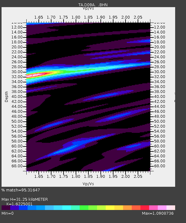
| Estimated Moho Depth: |
31.25 km |
| Estimated Crust Vp/Vs: |
1.62 |
| Assumed Crust Vp: |
6.419 km/s |
| Estimated Crust Vs: |
3.956 km/s |
| Estimated Crust Poisson's Ratio: |
0.19 |
|
| Radial Match: |
95.31647 % |
| Radial Bump: |
371 |
| Transverse Match: |
93.52696 % |
| Transverse Bump: |
368 |
| SOD ConfigId: |
2564 |
| Insert Time: |
2010-03-07 02:58:35.033 +0000 |
| GWidth: |
2.5 |
| Max Bumps: |
400 |
| Tol: |
0.001 |
|
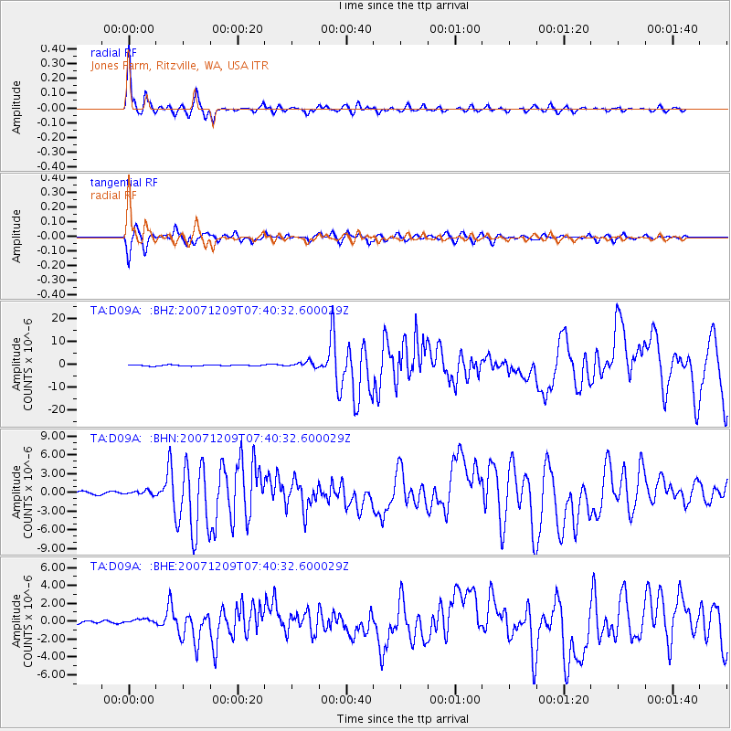
Signal To Noise
| Channel | StoN | STA | LTA |
| TA:D09A: :BHN:20071209T07:40:32.600029Z | 1.9527367 | 3.2889824E-7 | 1.6842938E-7 |
| TA:D09A: :BHE:20071209T07:40:32.600029Z | 1.8752903 | 2.550529E-7 | 1.3600716E-7 |
| TA:D09A: :BHZ:20071209T07:40:32.600029Z | 6.243288 | 1.3201524E-6 | 2.1145146E-7 |
| Arrivals |
| Ps | 3.1 SECOND |
| PpPs | 12 SECOND |
| PsPs/PpSs | 16 SECOND |


