You are here: Home > Network List > TA - USArray Transportable Network (new EarthScope stations) Stations List
> Station D09A Jones Farm, Ritzville, WA, USA > Earthquake Result Viewer
D09A Jones Farm, Ritzville, WA, USA - Earthquake Result Viewer
| Earthquake location: |
Near Coast Of Northern Chile |
| Earthquake latitude/longitude: |
-22.9/-70.2 |
| Earthquake time(UTC): |
2007/11/15 (319) 15:05:58 GMT |
| Earthquake Depth: |
26 km |
| Earthquake Magnitude: |
6.1 MB, 6.6 MS, 6.8 MW, 6.6 MW |
| Earthquake Catalog/Contributor: |
WHDF/NEIC |
|
| Network: |
TA USArray Transportable Network (new EarthScope stations) |
| Station: |
D09A Jones Farm, Ritzville, WA, USA |
| Lat/Lon: |
47.06 N/118.31 W |
| Elevation: |
540 m |
|
| Distance: |
82.0 deg |
| Az: |
329.097 deg |
| Baz: |
136.164 deg |
| Ray Param: |
0.047134165 |
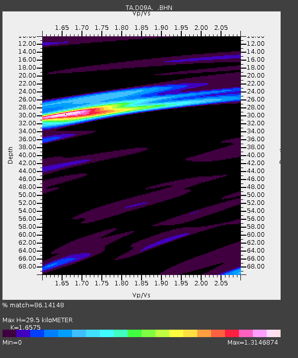
| Estimated Moho Depth: |
29.5 km |
| Estimated Crust Vp/Vs: |
1.66 |
| Assumed Crust Vp: |
6.419 km/s |
| Estimated Crust Vs: |
3.873 km/s |
| Estimated Crust Poisson's Ratio: |
0.21 |
|
| Radial Match: |
86.14148 % |
| Radial Bump: |
400 |
| Transverse Match: |
74.654205 % |
| Transverse Bump: |
400 |
| SOD ConfigId: |
2564 |
| Insert Time: |
2010-03-07 02:58:37.203 +0000 |
| GWidth: |
2.5 |
| Max Bumps: |
400 |
| Tol: |
0.001 |
|

Signal To Noise
| Channel | StoN | STA | LTA |
| TA:D09A: :BHN:20071115T15:17:44.875024Z | 0.8327059 | 2.2535295E-7 | 2.706273E-7 |
| TA:D09A: :BHE:20071115T15:17:44.875024Z | 2.2474563 | 6.8345184E-7 | 3.0410015E-7 |
| TA:D09A: :BHZ:20071115T15:17:44.875024Z | 2.8779001 | 1.2626892E-6 | 4.3875366E-7 |
| Arrivals |
| Ps | 3.1 SECOND |
| PpPs | 12 SECOND |
| PsPs/PpSs | 15 SECOND |


