You are here: Home > Network List > GS - US Geological Survey Networks Stations List
> Station OK031 2598 S. Brethren Rd., Cushing, OK, USA > Earthquake Result Viewer
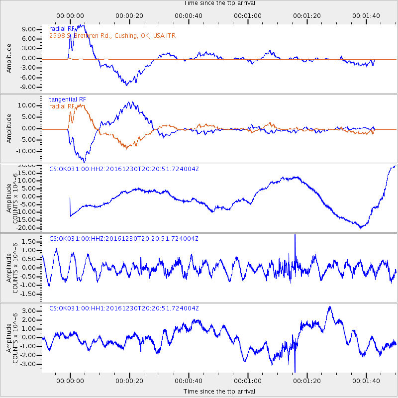
OK031 2598 S. Brethren Rd., Cushing, OK, USA - Earthquake Result Viewer
*The percent match for this event was below the threshold and hence no stack was calculated.
| Earthquake location: |
Near East Coast Of Honshu, Japan |
| Earthquake latitude/longitude: |
37.4/141.4 |
| Earthquake time(UTC): |
2016/12/30 (365) 20:08:27 GMT |
| Earthquake Depth: |
12 km |
| Earthquake Magnitude: |
5.5 mb |
| Earthquake Catalog/Contributor: |
NEIC PDE/us |
|
| Network: |
GS US Geological Survey Networks |
| Station: |
OK031 2598 S. Brethren Rd., Cushing, OK, USA |
| Lat/Lon: |
35.95 N/96.84 W |
| Elevation: |
290 m |
|
| Distance: |
89.2 deg |
| Az: |
43.631 deg |
| Baz: |
317.368 deg |
| Ray Param: |
$rayparam |
*The percent match for this event was below the threshold and hence was not used in the summary stack. |
|
| Radial Match: |
78.0447 % |
| Radial Bump: |
400 |
| Transverse Match: |
82.36192 % |
| Transverse Bump: |
400 |
| SOD ConfigId: |
1943534 |
| Insert Time: |
2017-01-13 20:09:49.818 +0000 |
| GWidth: |
2.5 |
| Max Bumps: |
400 |
| Tol: |
0.001 |
|
Signal To Noise
| Channel | StoN | STA | LTA |
| GS:OK031:00:HHZ:20161230T20:20:51.724004Z | 1.4543469 | 5.426137E-7 | 3.7309786E-7 |
| GS:OK031:00:HH1:20161230T20:20:51.724004Z | 0.5155865 | 5.001112E-7 | 9.69985E-7 |
| GS:OK031:00:HH2:20161230T20:20:51.724004Z | 0.9855477 | 5.0291087E-6 | 5.1028564E-6 |
| Arrivals |
| Ps | |
| PpPs | |
| PsPs/PpSs | |


