You are here: Home > Network List > TA - USArray Transportable Network (new EarthScope stations) Stations List
> Station D09A Jones Farm, Ritzville, WA, USA > Earthquake Result Viewer
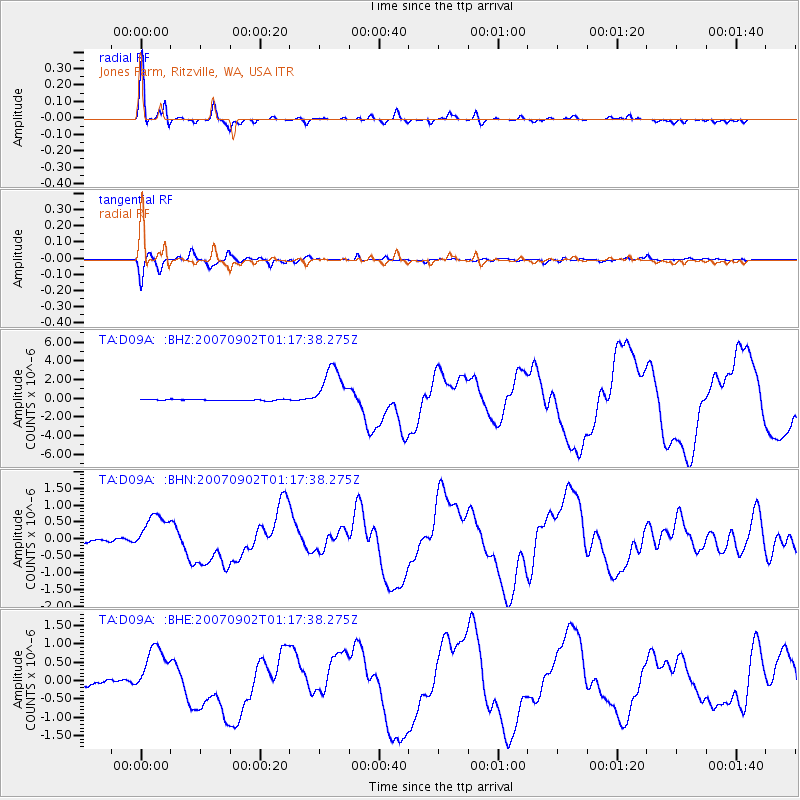
D09A Jones Farm, Ritzville, WA, USA - Earthquake Result Viewer
| Earthquake location: |
Santa Cruz Islands |
| Earthquake latitude/longitude: |
-11.6/165.8 |
| Earthquake time(UTC): |
2007/09/02 (245) 01:05:18 GMT |
| Earthquake Depth: |
35 km |
| Earthquake Magnitude: |
5.9 MB, 7.3 MS, 7.2 MW, 6.9 ME |
| Earthquake Catalog/Contributor: |
WHDF/NEIC |
|
| Network: |
TA USArray Transportable Network (new EarthScope stations) |
| Station: |
D09A Jones Farm, Ritzville, WA, USA |
| Lat/Lon: |
47.06 N/118.31 W |
| Elevation: |
540 m |
|
| Distance: |
89.0 deg |
| Az: |
41.548 deg |
| Baz: |
251.905 deg |
| Ray Param: |
0.042102866 |
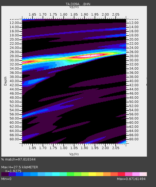
| Estimated Moho Depth: |
27.5 km |
| Estimated Crust Vp/Vs: |
1.93 |
| Assumed Crust Vp: |
6.419 km/s |
| Estimated Crust Vs: |
3.33 km/s |
| Estimated Crust Poisson's Ratio: |
0.32 |
|
| Radial Match: |
97.818344 % |
| Radial Bump: |
308 |
| Transverse Match: |
94.03329 % |
| Transverse Bump: |
331 |
| SOD ConfigId: |
2564 |
| Insert Time: |
2010-03-07 02:58:45.183 +0000 |
| GWidth: |
2.5 |
| Max Bumps: |
400 |
| Tol: |
0.001 |
|
Signal To Noise
| Channel | StoN | STA | LTA |
| TA:D09A: :BHN:20070902T01:17:38.275Z | 9.457399 | 5.6295767E-7 | 5.9525632E-8 |
| TA:D09A: :BHE:20070902T01:17:38.275Z | 9.340305 | 6.937502E-7 | 7.42749E-8 |
| TA:D09A: :BHZ:20070902T01:17:38.275Z | 35.843304 | 2.384271E-6 | 6.6519284E-8 |
| Arrivals |
| Ps | 4.1 SECOND |
| PpPs | 12 SECOND |
| PsPs/PpSs | 16 SECOND |


