You are here: Home > Network List > TA - USArray Transportable Network (new EarthScope stations) Stations List
> Station D09A Jones Farm, Ritzville, WA, USA > Earthquake Result Viewer
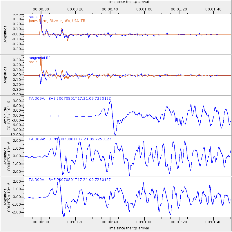
D09A Jones Farm, Ritzville, WA, USA - Earthquake Result Viewer

| Earthquake location: |
Vanuatu Islands |
| Earthquake latitude/longitude: |
-15.6/167.7 |
| Earthquake time(UTC): |
2007/08/01 (213) 17:08:51 GMT |
| Earthquake Depth: |
120 km |
| Earthquake Magnitude: |
6.2 MB, 7.2 MW, 7.2 MW |
| Earthquake Catalog/Contributor: |
WHDF/NEIC |
|
| Network: |
TA USArray Transportable Network (new EarthScope stations) |
| Station: |
D09A Jones Farm, Ritzville, WA, USA |
| Lat/Lon: |
47.06 N/118.31 W |
| Elevation: |
540 m |
|
| Distance: |
90.8 deg |
| Az: |
41.092 deg |
| Baz: |
247.889 deg |
| Ray Param: |
0.04162521 |
| Estimated Moho Depth: |
30.5 km |
| Estimated Crust Vp/Vs: |
1.64 |
| Assumed Crust Vp: |
6.419 km/s |
| Estimated Crust Vs: |
3.92 km/s |
| Estimated Crust Poisson's Ratio: |
0.20 |
|
| Radial Match: |
96.10336 % |
| Radial Bump: |
260 |
| Transverse Match: |
92.74442 % |
| Transverse Bump: |
287 |
| SOD ConfigId: |
2564 |
| Insert Time: |
2010-03-07 02:59:00.367 +0000 |
| GWidth: |
2.5 |
| Max Bumps: |
400 |
| Tol: |
0.001 |
|
Signal To Noise
| Channel | StoN | STA | LTA |
| TA:D09A: :BHN:20070801T17:21:09.725012Z | 4.8475523 | 1.7408027E-7 | 3.591096E-8 |
| TA:D09A: :BHE:20070801T17:21:09.725012Z | 2.6294813 | 1.6519441E-7 | 6.282396E-8 |
| TA:D09A: :BHZ:20070801T17:21:09.725012Z | 7.102071 | 7.432733E-7 | 1.04655854E-7 |
| Arrivals |
| Ps | 3.1 SECOND |
| PpPs | 12 SECOND |
| PsPs/PpSs | 15 SECOND |


