You are here: Home > Network List > IU - Global Seismograph Network (GSN - IRIS/USGS) Stations List
> Station XMAS Kiritimati Island, Republic of Kiribati > Earthquake Result Viewer
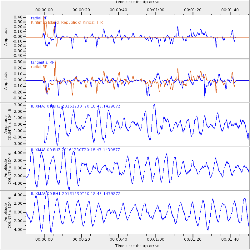
XMAS Kiritimati Island, Republic of Kiribati - Earthquake Result Viewer
*The percent match for this event was below the threshold and hence no stack was calculated.
| Earthquake location: |
Near East Coast Of Honshu, Japan |
| Earthquake latitude/longitude: |
37.4/141.4 |
| Earthquake time(UTC): |
2016/12/30 (365) 20:08:27 GMT |
| Earthquake Depth: |
12 km |
| Earthquake Magnitude: |
5.5 mb |
| Earthquake Catalog/Contributor: |
NEIC PDE/us |
|
| Network: |
IU Global Seismograph Network (GSN - IRIS/USGS) |
| Station: |
XMAS Kiritimati Island, Republic of Kiribati |
| Lat/Lon: |
2.04 N/157.45 W |
| Elevation: |
20 m |
|
| Distance: |
66.1 deg |
| Az: |
106.751 deg |
| Baz: |
310.263 deg |
| Ray Param: |
$rayparam |
*The percent match for this event was below the threshold and hence was not used in the summary stack. |
|
| Radial Match: |
64.60119 % |
| Radial Bump: |
400 |
| Transverse Match: |
66.066154 % |
| Transverse Bump: |
400 |
| SOD ConfigId: |
1943534 |
| Insert Time: |
2017-01-13 20:10:44.984 +0000 |
| GWidth: |
2.5 |
| Max Bumps: |
400 |
| Tol: |
0.001 |
|
Signal To Noise
| Channel | StoN | STA | LTA |
| IU:XMAS:00:BHZ:20161230T20:18:43.143987Z | 1.3898335 | 2.5647357E-6 | 1.8453546E-6 |
| IU:XMAS:00:BH1:20161230T20:18:43.143987Z | 2.7583497 | 3.2664448E-6 | 1.1842026E-6 |
| IU:XMAS:00:BH2:20161230T20:18:43.143987Z | 1.1519694 | 1.8820232E-6 | 1.633744E-6 |
| Arrivals |
| Ps | |
| PpPs | |
| PsPs/PpSs | |


