You are here: Home > Network List > TA - USArray Transportable Network (new EarthScope stations) Stations List
> Station D09A Jones Farm, Ritzville, WA, USA > Earthquake Result Viewer
D09A Jones Farm, Ritzville, WA, USA - Earthquake Result Viewer
| Earthquake location: |
Vanuatu Islands |
| Earthquake latitude/longitude: |
-15.4/168.6 |
| Earthquake time(UTC): |
2007/07/15 (196) 09:27:34 GMT |
| Earthquake Depth: |
8.0 km |
| Earthquake Magnitude: |
6.0 MB, 5.8 MS, 6.1 MW, 6.0 MW |
| Earthquake Catalog/Contributor: |
WHDF/NEIC |
|
| Network: |
TA USArray Transportable Network (new EarthScope stations) |
| Station: |
D09A Jones Farm, Ritzville, WA, USA |
| Lat/Lon: |
47.06 N/118.31 W |
| Elevation: |
540 m |
|
| Distance: |
90.0 deg |
| Az: |
40.853 deg |
| Baz: |
247.359 deg |
| Ray Param: |
0.04170245 |
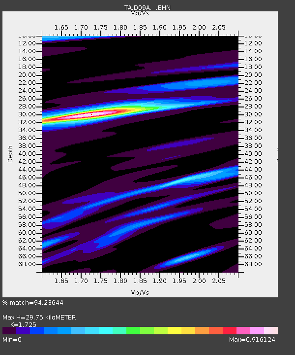
| Estimated Moho Depth: |
29.75 km |
| Estimated Crust Vp/Vs: |
1.73 |
| Assumed Crust Vp: |
6.419 km/s |
| Estimated Crust Vs: |
3.721 km/s |
| Estimated Crust Poisson's Ratio: |
0.25 |
|
| Radial Match: |
94.23644 % |
| Radial Bump: |
317 |
| Transverse Match: |
90.53363 % |
| Transverse Bump: |
374 |
| SOD ConfigId: |
2564 |
| Insert Time: |
2010-03-07 02:59:08.182 +0000 |
| GWidth: |
2.5 |
| Max Bumps: |
400 |
| Tol: |
0.001 |
|

Signal To Noise
| Channel | StoN | STA | LTA |
| TA:D09A: :BHN:20070715T09:40:03.00002Z | 13.712724 | 6.5666705E-7 | 4.7887426E-8 |
| TA:D09A: :BHE:20070715T09:40:03.00002Z | 11.651386 | 4.5858002E-7 | 3.9358408E-8 |
| TA:D09A: :BHZ:20070715T09:40:03.00002Z | 57.510693 | 2.5636975E-6 | 4.4577753E-8 |
| Arrivals |
| Ps | 3.4 SECOND |
| PpPs | 12 SECOND |
| PsPs/PpSs | 16 SECOND |


