You are here: Home > Network List > TA - USArray Transportable Network (new EarthScope stations) Stations List
> Station D09A Jones Farm, Ritzville, WA, USA > Earthquake Result Viewer
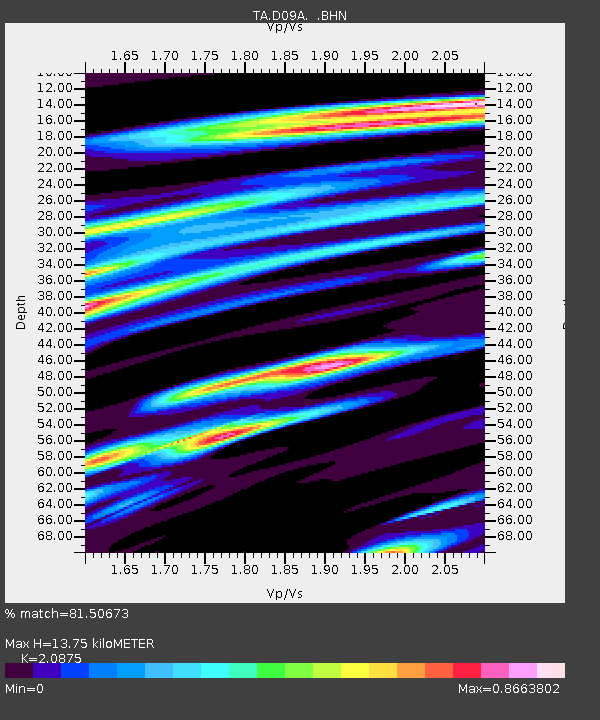
D09A Jones Farm, Ritzville, WA, USA - Earthquake Result Viewer
| Earthquake location: |
Gulf Of Mexico |
| Earthquake latitude/longitude: |
21.9/-96.4 |
| Earthquake time(UTC): |
2007/05/23 (143) 19:09:15 GMT |
| Earthquake Depth: |
10 km |
| Earthquake Magnitude: |
5.6 MW, 4.8 MS, 5.4 MB |
| Earthquake Catalog/Contributor: |
WHDF/NEIC |
|
| Network: |
TA USArray Transportable Network (new EarthScope stations) |
| Station: |
D09A Jones Farm, Ritzville, WA, USA |
| Lat/Lon: |
47.06 N/118.31 W |
| Elevation: |
540 m |
|
| Distance: |
30.7 deg |
| Az: |
330.006 deg |
| Baz: |
137.225 deg |
| Ray Param: |
0.079251796 |
| Estimated Moho Depth: |
13.75 km |
| Estimated Crust Vp/Vs: |
2.09 |
| Assumed Crust Vp: |
6.419 km/s |
| Estimated Crust Vs: |
3.075 km/s |
| Estimated Crust Poisson's Ratio: |
0.35 |
|
| Radial Match: |
81.50673 % |
| Radial Bump: |
355 |
| Transverse Match: |
64.80031 % |
| Transverse Bump: |
400 |
| SOD ConfigId: |
2564 |
| Insert Time: |
2010-03-07 02:59:16.020 +0000 |
| GWidth: |
2.5 |
| Max Bumps: |
400 |
| Tol: |
0.001 |
|

Signal To Noise
| Channel | StoN | STA | LTA |
| TA:D09A: :BHN:20070523T19:14:59.748011Z | 6.511269 | 3.2838278E-7 | 5.0432995E-8 |
| TA:D09A: :BHE:20070523T19:14:59.748011Z | 7.811578 | 4.53506E-7 | 5.8055623E-8 |
| TA:D09A: :BHZ:20070523T19:14:59.748011Z | 8.143695 | 7.814794E-7 | 9.596128E-8 |
| Arrivals |
| Ps | 2.5 SECOND |
| PpPs | 6.2 SECOND |
| PsPs/PpSs | 8.7 SECOND |


