You are here: Home > Network List > TA - USArray Transportable Network (new EarthScope stations) Stations List
> Station D09A Jones Farm, Ritzville, WA, USA > Earthquake Result Viewer
D09A Jones Farm, Ritzville, WA, USA - Earthquake Result Viewer
| Earthquake location: |
Near West Coast Of Honshu, Japan |
| Earthquake latitude/longitude: |
37.3/136.6 |
| Earthquake time(UTC): |
2007/03/25 (084) 00:41:57 GMT |
| Earthquake Depth: |
8.0 km |
| Earthquake Magnitude: |
6.1 MB, 6.8 MS, 6.7 MW, 6.6 MW |
| Earthquake Catalog/Contributor: |
WHDF/NEIC |
|
| Network: |
TA USArray Transportable Network (new EarthScope stations) |
| Station: |
D09A Jones Farm, Ritzville, WA, USA |
| Lat/Lon: |
47.06 N/118.31 W |
| Elevation: |
540 m |
|
| Distance: |
72.6 deg |
| Az: |
43.76 deg |
| Baz: |
306.259 deg |
| Ray Param: |
0.053546485 |
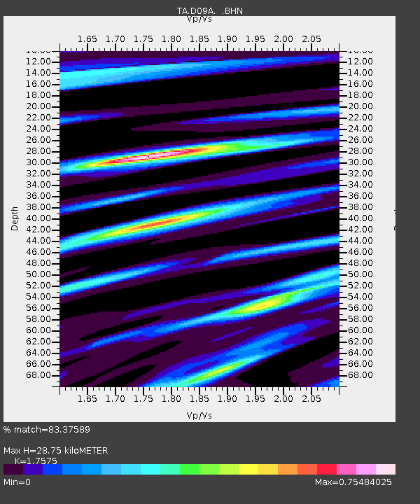
| Estimated Moho Depth: |
28.75 km |
| Estimated Crust Vp/Vs: |
1.76 |
| Assumed Crust Vp: |
6.419 km/s |
| Estimated Crust Vs: |
3.652 km/s |
| Estimated Crust Poisson's Ratio: |
0.26 |
|
| Radial Match: |
83.37589 % |
| Radial Bump: |
400 |
| Transverse Match: |
91.025955 % |
| Transverse Bump: |
400 |
| SOD ConfigId: |
2564 |
| Insert Time: |
2010-03-07 02:59:17.141 +0000 |
| GWidth: |
2.5 |
| Max Bumps: |
400 |
| Tol: |
0.001 |
|
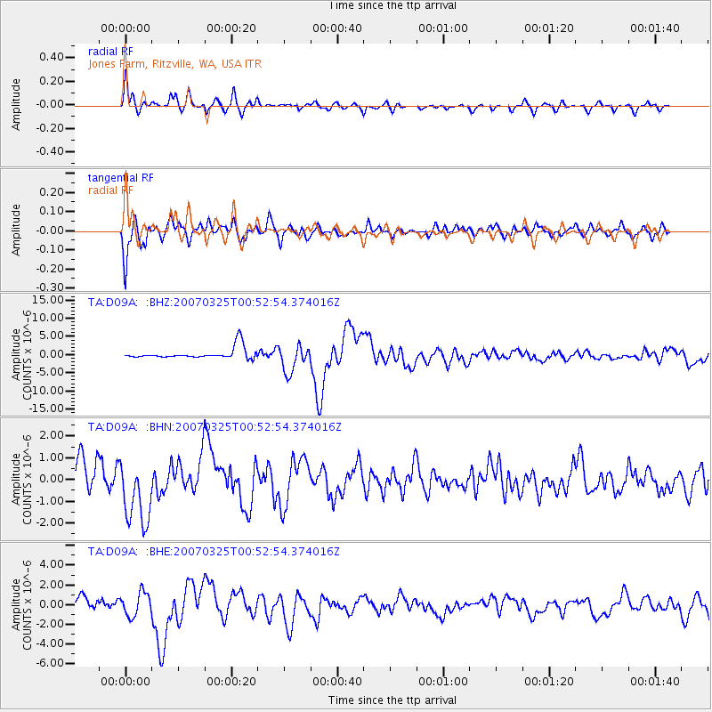
Signal To Noise
| Channel | StoN | STA | LTA |
| TA:D09A: :BHN:20070325T00:52:54.374016Z | 3.9933622 | 1.6124449E-6 | 4.0378129E-7 |
| TA:D09A: :BHE:20070325T00:52:54.374016Z | 3.5670447 | 1.2000086E-6 | 3.3641533E-7 |
| TA:D09A: :BHZ:20070325T00:52:54.374016Z | 2.4255104 | 3.7504935E-6 | 1.5462699E-6 |
| Arrivals |
| Ps | 3.5 SECOND |
| PpPs | 12 SECOND |
| PsPs/PpSs | 15 SECOND |


