You are here: Home > Network List > TA - USArray Transportable Network (new EarthScope stations) Stations List
> Station D09A Jones Farm, Ritzville, WA, USA > Earthquake Result Viewer
D09A Jones Farm, Ritzville, WA, USA - Earthquake Result Viewer

| Earthquake location: |
Kuril Islands |
| Earthquake latitude/longitude: |
46.6/153.3 |
| Earthquake time(UTC): |
2006/11/15 (319) 11:14:13 GMT |
| Earthquake Depth: |
10 km |
| Earthquake Magnitude: |
6.5 MB, 7.8 MS, 8.3 MW, 7.9 MW |
| Earthquake Catalog/Contributor: |
WHDF/NEIC |
|
| Network: |
TA USArray Transportable Network (new EarthScope stations) |
| Station: |
D09A Jones Farm, Ritzville, WA, USA |
| Lat/Lon: |
47.06 N/118.31 W |
| Elevation: |
540 m |
|
| Distance: |
57.2 deg |
| Az: |
54.377 deg |
| Baz: |
304.919 deg |
| Ray Param: |
0.063631475 |
| Estimated Moho Depth: |
29.0 km |
| Estimated Crust Vp/Vs: |
1.75 |
| Assumed Crust Vp: |
6.419 km/s |
| Estimated Crust Vs: |
3.663 km/s |
| Estimated Crust Poisson's Ratio: |
0.26 |
|
| Radial Match: |
98.33047 % |
| Radial Bump: |
201 |
| Transverse Match: |
95.96053 % |
| Transverse Bump: |
293 |
| SOD ConfigId: |
2564 |
| Insert Time: |
2010-03-07 02:59:22.890 +0000 |
| GWidth: |
2.5 |
| Max Bumps: |
400 |
| Tol: |
0.001 |
|
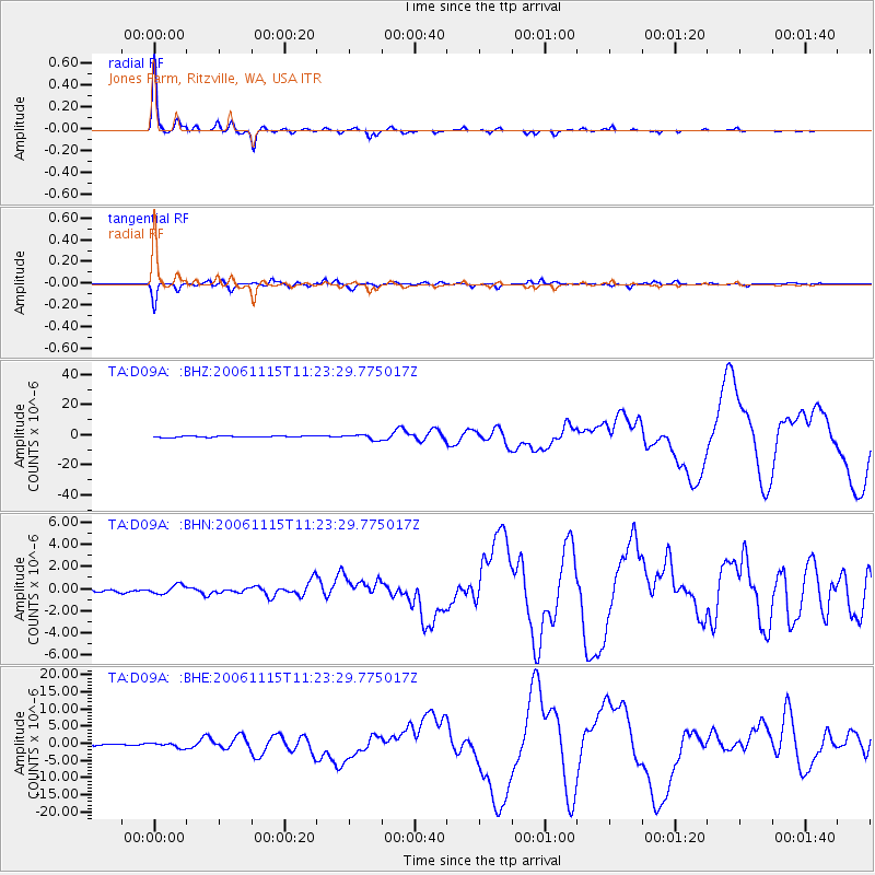
Signal To Noise
| Channel | StoN | STA | LTA |
| TA:D09A: :BHN:20061115T11:23:29.775017Z | 1.2165927 | 3.9285035E-7 | 3.2291032E-7 |
| TA:D09A: :BHE:20061115T11:23:29.775017Z | 2.7545214 | 6.837479E-7 | 2.4822748E-7 |
| TA:D09A: :BHZ:20061115T11:23:29.775017Z | 3.6197007 | 1.705225E-6 | 4.7109557E-7 |
| Arrivals |
| Ps | 3.6 SECOND |
| PpPs | 12 SECOND |
| PsPs/PpSs | 15 SECOND |


