You are here: Home > Network List > TA - USArray Transportable Network (new EarthScope stations) Stations List
> Station D09A Jones Farm, Ritzville, WA, USA > Earthquake Result Viewer
D09A Jones Farm, Ritzville, WA, USA - Earthquake Result Viewer

| Earthquake location: |
Trinidad |
| Earthquake latitude/longitude: |
10.9/-61.8 |
| Earthquake time(UTC): |
2006/09/29 (272) 13:08:26 GMT |
| Earthquake Depth: |
53 km |
| Earthquake Magnitude: |
5.9 MB, 5.4 MS, 6.1 MW, 6.0 MW |
| Earthquake Catalog/Contributor: |
WHDF/NEIC |
|
| Network: |
TA USArray Transportable Network (new EarthScope stations) |
| Station: |
D09A Jones Farm, Ritzville, WA, USA |
| Lat/Lon: |
47.06 N/118.31 W |
| Elevation: |
540 m |
|
| Distance: |
59.5 deg |
| Az: |
318.564 deg |
| Baz: |
108.04 deg |
| Ray Param: |
0.061996512 |
| Estimated Moho Depth: |
31.5 km |
| Estimated Crust Vp/Vs: |
1.63 |
| Assumed Crust Vp: |
6.419 km/s |
| Estimated Crust Vs: |
3.944 km/s |
| Estimated Crust Poisson's Ratio: |
0.20 |
|
| Radial Match: |
82.3507 % |
| Radial Bump: |
400 |
| Transverse Match: |
64.95387 % |
| Transverse Bump: |
400 |
| SOD ConfigId: |
2665 |
| Insert Time: |
2010-03-07 02:59:28.300 +0000 |
| GWidth: |
2.5 |
| Max Bumps: |
400 |
| Tol: |
0.001 |
|
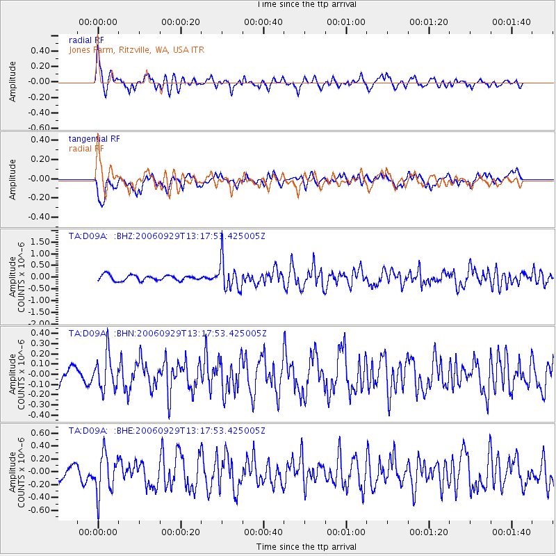
Signal To Noise
| Channel | StoN | STA | LTA |
| TA:D09A: :BHN:20060929T13:17:53.425005Z | 1.4701312 | 1.7616475E-7 | 1.1982927E-7 |
| TA:D09A: :BHE:20060929T13:17:53.425005Z | 3.0366855 | 3.178184E-7 | 1.04659634E-7 |
| TA:D09A: :BHZ:20060929T13:17:53.425005Z | 5.5899796 | 6.486283E-7 | 1.16034116E-7 |
| Arrivals |
| Ps | 3.2 SECOND |
| PpPs | 12 SECOND |
| PsPs/PpSs | 15 SECOND |


