You are here: Home > Network List > TA - USArray Transportable Network (new EarthScope stations) Stations List
> Station D23K Nanushuk River, AK USA > Earthquake Result Viewer
D23K Nanushuk River, AK USA - Earthquake Result Viewer

| Earthquake location: |
Vanuatu Islands |
| Earthquake latitude/longitude: |
-15.5/167.7 |
| Earthquake time(UTC): |
2019/08/07 (219) 05:32:40 GMT |
| Earthquake Depth: |
123 km |
| Earthquake Magnitude: |
5.8 Mww |
| Earthquake Catalog/Contributor: |
NEIC PDE/us |
|
| Network: |
TA USArray Transportable Network (new EarthScope stations) |
| Station: |
D23K Nanushuk River, AK USA |
| Lat/Lon: |
68.97 N/150.68 W |
| Elevation: |
406 m |
|
| Distance: |
89.3 deg |
| Az: |
13.874 deg |
| Baz: |
219.813 deg |
| Ray Param: |
0.041730322 |
| Estimated Moho Depth: |
36.75 km |
| Estimated Crust Vp/Vs: |
1.92 |
| Assumed Crust Vp: |
6.221 km/s |
| Estimated Crust Vs: |
3.236 km/s |
| Estimated Crust Poisson's Ratio: |
0.31 |
|
| Radial Match: |
82.33511 % |
| Radial Bump: |
400 |
| Transverse Match: |
64.85904 % |
| Transverse Bump: |
400 |
| SOD ConfigId: |
19053131 |
| Insert Time: |
2019-08-21 05:39:12.769 +0000 |
| GWidth: |
2.5 |
| Max Bumps: |
400 |
| Tol: |
0.001 |
|
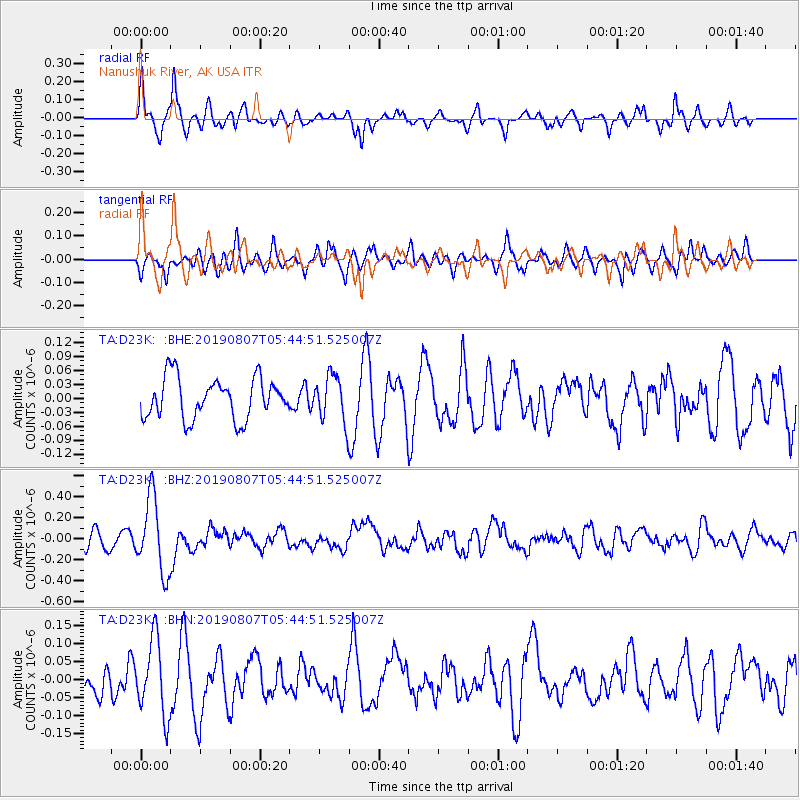
Signal To Noise
| Channel | StoN | STA | LTA |
| TA:D23K: :BHZ:20190807T05:44:51.525007Z | 4.523774 | 3.538828E-7 | 7.822734E-8 |
| TA:D23K: :BHN:20190807T05:44:51.525007Z | 1.4711542 | 1.0503054E-7 | 7.139329E-8 |
| TA:D23K: :BHE:20190807T05:44:51.525007Z | 1.1499352 | 4.994328E-8 | 4.3431385E-8 |
| Arrivals |
| Ps | 5.5 SECOND |
| PpPs | 17 SECOND |
| PsPs/PpSs | 23 SECOND |


