You are here: Home > Network List > TA - USArray Transportable Network (new EarthScope stations) Stations List
> Station H16K Elim, AK, USA > Earthquake Result Viewer
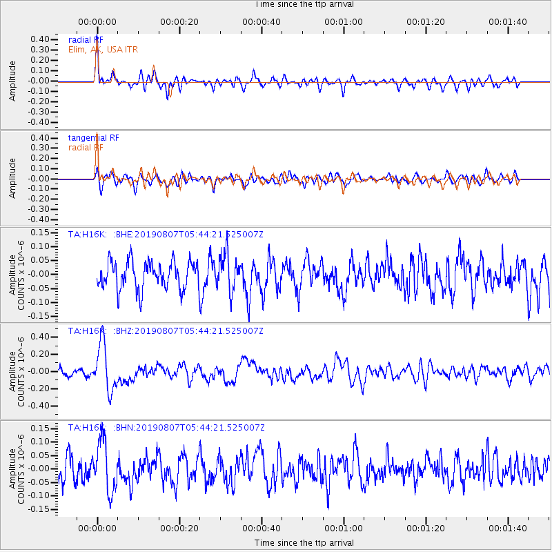
H16K Elim, AK, USA - Earthquake Result Viewer
*The percent match for this event was below the threshold and hence no stack was calculated.
| Earthquake location: |
Vanuatu Islands |
| Earthquake latitude/longitude: |
-15.5/167.7 |
| Earthquake time(UTC): |
2019/08/07 (219) 05:32:40 GMT |
| Earthquake Depth: |
123 km |
| Earthquake Magnitude: |
5.8 Mww |
| Earthquake Catalog/Contributor: |
NEIC PDE/us |
|
| Network: |
TA USArray Transportable Network (new EarthScope stations) |
| Station: |
H16K Elim, AK, USA |
| Lat/Lon: |
64.64 N/162.24 W |
| Elevation: |
216 m |
|
| Distance: |
83.1 deg |
| Az: |
12.548 deg |
| Baz: |
209.099 deg |
| Ray Param: |
$rayparam |
*The percent match for this event was below the threshold and hence was not used in the summary stack. |
|
| Radial Match: |
70.37568 % |
| Radial Bump: |
400 |
| Transverse Match: |
57.80796 % |
| Transverse Bump: |
400 |
| SOD ConfigId: |
19053131 |
| Insert Time: |
2019-08-21 05:39:36.059 +0000 |
| GWidth: |
2.5 |
| Max Bumps: |
400 |
| Tol: |
0.001 |
|
Signal To Noise
| Channel | StoN | STA | LTA |
| TA:H16K: :BHZ:20190807T05:44:21.525007Z | 3.994132 | 2.8153718E-7 | 7.04877E-8 |
| TA:H16K: :BHN:20190807T05:44:21.525007Z | 2.5382988 | 9.662734E-8 | 3.8067757E-8 |
| TA:H16K: :BHE:20190807T05:44:21.525007Z | 1.3135253 | 6.4932074E-8 | 4.9433435E-8 |
| Arrivals |
| Ps | |
| PpPs | |
| PsPs/PpSs | |


