You are here: Home > Network List > IU - Global Seismograph Network (GSN - IRIS/USGS) Stations List
> Station JOHN Johnston Island, USA > Earthquake Result Viewer
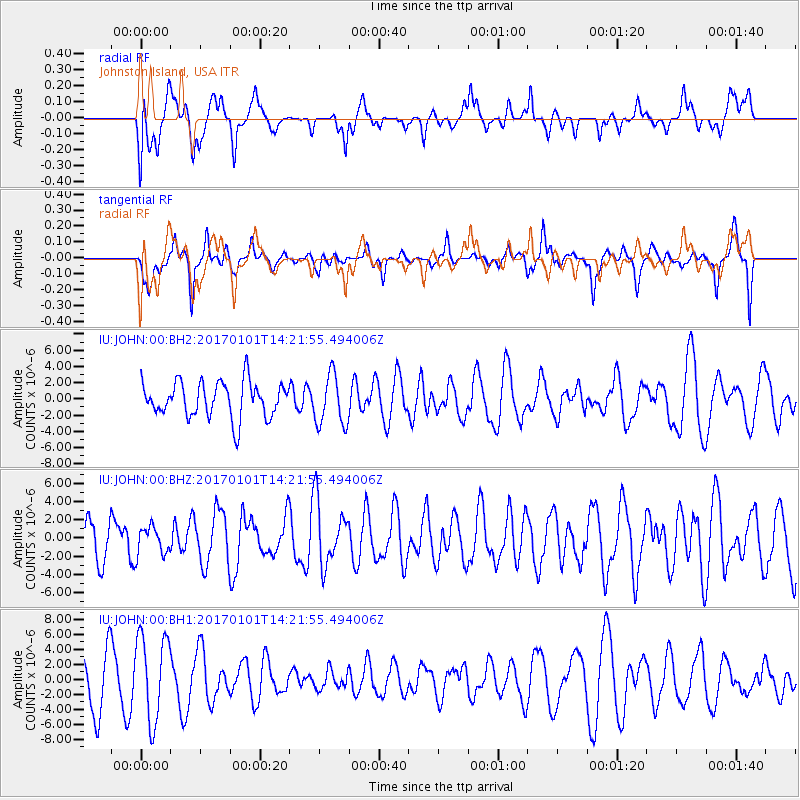
JOHN Johnston Island, USA - Earthquake Result Viewer
*The percent match for this event was below the threshold and hence no stack was calculated.
| Earthquake location: |
North Of Halmahera, Indonesia |
| Earthquake latitude/longitude: |
3.6/128.6 |
| Earthquake time(UTC): |
2017/01/01 (001) 14:12:09 GMT |
| Earthquake Depth: |
35 km |
| Earthquake Magnitude: |
5.5 mb |
| Earthquake Catalog/Contributor: |
NEIC PDE/us |
|
| Network: |
IU Global Seismograph Network (GSN - IRIS/USGS) |
| Station: |
JOHN Johnston Island, USA |
| Lat/Lon: |
16.73 N/169.53 W |
| Elevation: |
2.0 m |
|
| Distance: |
62.1 deg |
| Az: |
73.075 deg |
| Baz: |
265.177 deg |
| Ray Param: |
$rayparam |
*The percent match for this event was below the threshold and hence was not used in the summary stack. |
|
| Radial Match: |
46.42248 % |
| Radial Bump: |
400 |
| Transverse Match: |
47.19232 % |
| Transverse Bump: |
317 |
| SOD ConfigId: |
1943534 |
| Insert Time: |
2017-01-15 14:14:27.404 +0000 |
| GWidth: |
2.5 |
| Max Bumps: |
400 |
| Tol: |
0.001 |
|
Signal To Noise
| Channel | StoN | STA | LTA |
| IU:JOHN:00:BHZ:20170101T14:21:55.494006Z | 0.65186846 | 1.50262E-6 | 2.3050968E-6 |
| IU:JOHN:00:BH1:20170101T14:21:55.494006Z | 1.7996578 | 5.757213E-6 | 3.1990596E-6 |
| IU:JOHN:00:BH2:20170101T14:21:55.494006Z | 1.424337 | 3.1178265E-6 | 2.1889668E-6 |
| Arrivals |
| Ps | |
| PpPs | |
| PsPs/PpSs | |


