You are here: Home > Network List > TA - USArray Transportable Network (new EarthScope stations) Stations List
> Station D09A Jones Farm, Ritzville, WA, USA > Earthquake Result Viewer
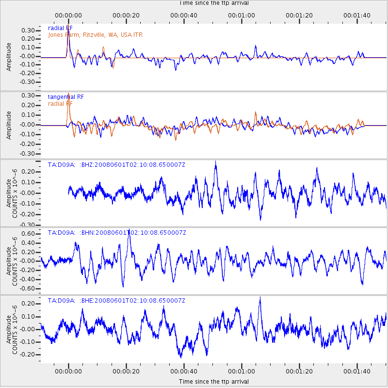
D09A Jones Farm, Ritzville, WA, USA - Earthquake Result Viewer
*The percent match for this event was below the threshold and hence no stack was calculated.
| Earthquake location: |
Philippine Islands Region |
| Earthquake latitude/longitude: |
20.1/121.4 |
| Earthquake time(UTC): |
2008/06/01 (153) 01:57:24 GMT |
| Earthquake Depth: |
35 km |
| Earthquake Magnitude: |
6.0 MB, 6.2 MS, 6.3 MW, 6.2 MW |
| Earthquake Catalog/Contributor: |
WHDF/NEIC |
|
| Network: |
TA USArray Transportable Network (new EarthScope stations) |
| Station: |
D09A Jones Farm, Ritzville, WA, USA |
| Lat/Lon: |
47.06 N/118.31 W |
| Elevation: |
540 m |
|
| Distance: |
94.3 deg |
| Az: |
36.285 deg |
| Baz: |
305.57 deg |
| Ray Param: |
$rayparam |
*The percent match for this event was below the threshold and hence was not used in the summary stack. |
|
| Radial Match: |
78.18895 % |
| Radial Bump: |
400 |
| Transverse Match: |
59.093487 % |
| Transverse Bump: |
400 |
| SOD ConfigId: |
2504 |
| Insert Time: |
2010-03-07 03:00:10.044 +0000 |
| GWidth: |
2.5 |
| Max Bumps: |
400 |
| Tol: |
0.001 |
|
Signal To Noise
| Channel | StoN | STA | LTA |
| TA:D09A: :BHN:20080601T02:10:08.650007Z | 4.3744025 | 2.088312E-7 | 4.7739366E-8 |
| TA:D09A: :BHE:20080601T02:10:08.650007Z | 1.1565641 | 5.352108E-8 | 4.627593E-8 |
| TA:D09A: :BHZ:20080601T02:10:08.650007Z | 2.1429167 | 7.4372615E-8 | 3.4706254E-8 |
| Arrivals |
| Ps | |
| PpPs | |
| PsPs/PpSs | |


