You are here: Home > Network List > UW - Pacific Northwest Regional Seismic Network Stations List
> Station LEBA Lebam, WA, USA > Earthquake Result Viewer
LEBA Lebam, WA, USA - Earthquake Result Viewer
*The percent match for this event was below the threshold and hence no stack was calculated.
| Earthquake location: |
Vanuatu Islands |
| Earthquake latitude/longitude: |
-15.5/167.7 |
| Earthquake time(UTC): |
2019/08/07 (219) 05:32:40 GMT |
| Earthquake Depth: |
123 km |
| Earthquake Magnitude: |
5.8 Mww |
| Earthquake Catalog/Contributor: |
NEIC PDE/us |
|
| Network: |
UW Pacific Northwest Regional Seismic Network |
| Station: |
LEBA Lebam, WA, USA |
| Lat/Lon: |
46.55 N/123.56 W |
| Elevation: |
73 m |
|
| Distance: |
87.2 deg |
| Az: |
40.089 deg |
| Baz: |
244.089 deg |
| Ray Param: |
$rayparam |
*The percent match for this event was below the threshold and hence was not used in the summary stack. |
|
| Radial Match: |
64.503624 % |
| Radial Bump: |
400 |
| Transverse Match: |
66.24548 % |
| Transverse Bump: |
400 |
| SOD ConfigId: |
19053131 |
| Insert Time: |
2019-08-21 05:41:25.292 +0000 |
| GWidth: |
2.5 |
| Max Bumps: |
400 |
| Tol: |
0.001 |
|
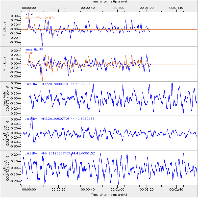
Signal To Noise
| Channel | StoN | STA | LTA |
| UW:LEBA: :HHZ:20190807T05:44:41.608015Z | 6.3305726 | 3.4686232E-7 | 5.479162E-8 |
| UW:LEBA: :HHN:20190807T05:44:41.608015Z | 1.1797544 | 8.917837E-8 | 7.559063E-8 |
| UW:LEBA: :HHE:20190807T05:44:41.608015Z | 1.2220017 | 9.359607E-8 | 7.659243E-8 |
| Arrivals |
| Ps | |
| PpPs | |
| PsPs/PpSs | |


