You are here: Home > Network List > TA - USArray Transportable Network (new EarthScope stations) Stations List
> Station C07A Waterville, WA, USA > Earthquake Result Viewer
C07A Waterville, WA, USA - Earthquake Result Viewer
| Earthquake location: |
Peru-Brazil Border Region |
| Earthquake latitude/longitude: |
-7.9/-74.4 |
| Earthquake time(UTC): |
2007/07/12 (193) 05:23:49 GMT |
| Earthquake Depth: |
152 km |
| Earthquake Magnitude: |
5.9 MB, 6.1 MW, 6.0 MW |
| Earthquake Catalog/Contributor: |
WHDF/NEIC |
|
| Network: |
TA USArray Transportable Network (new EarthScope stations) |
| Station: |
C07A Waterville, WA, USA |
| Lat/Lon: |
47.69 N/120.06 W |
| Elevation: |
863 m |
|
| Distance: |
68.5 deg |
| Az: |
328.7 deg |
| Baz: |
130.385 deg |
| Ray Param: |
0.055847663 |
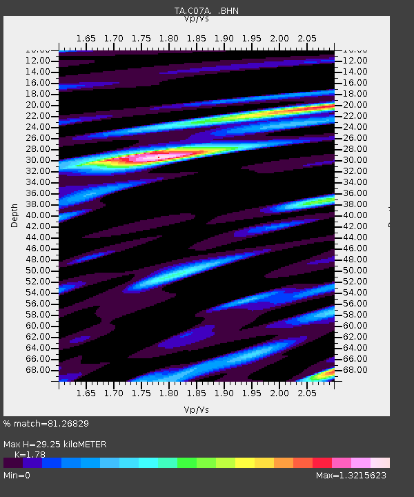
| Estimated Moho Depth: |
29.25 km |
| Estimated Crust Vp/Vs: |
1.78 |
| Assumed Crust Vp: |
6.597 km/s |
| Estimated Crust Vs: |
3.706 km/s |
| Estimated Crust Poisson's Ratio: |
0.27 |
|
| Radial Match: |
81.26829 % |
| Radial Bump: |
400 |
| Transverse Match: |
68.53873 % |
| Transverse Bump: |
400 |
| SOD ConfigId: |
2564 |
| Insert Time: |
2010-03-07 03:01:04.109 +0000 |
| GWidth: |
2.5 |
| Max Bumps: |
400 |
| Tol: |
0.001 |
|

Signal To Noise
| Channel | StoN | STA | LTA |
| TA:C07A: :BHN:20070712T05:34:04.35001Z | 2.1078205 | 1.6461959E-7 | 7.809944E-8 |
| TA:C07A: :BHE:20070712T05:34:04.35001Z | 4.9853983 | 3.04855E-7 | 6.114958E-8 |
| TA:C07A: :BHZ:20070712T05:34:04.35001Z | 11.277736 | 7.659944E-7 | 6.7920936E-8 |
| Arrivals |
| Ps | 3.6 SECOND |
| PpPs | 12 SECOND |
| PsPs/PpSs | 15 SECOND |


