You are here: Home > Network List > TA - USArray Transportable Network (new EarthScope stations) Stations List
> Station C07A Waterville, WA, USA > Earthquake Result Viewer
C07A Waterville, WA, USA - Earthquake Result Viewer
| Earthquake location: |
Fiji Islands Region |
| Earthquake latitude/longitude: |
-14.6/177.8 |
| Earthquake time(UTC): |
2007/03/30 (089) 15:58:44 GMT |
| Earthquake Depth: |
10 km |
| Earthquake Magnitude: |
5.7 MB, 5.3 MS, 5.7 MW, 5.7 MW |
| Earthquake Catalog/Contributor: |
WHDF/NEIC |
|
| Network: |
TA USArray Transportable Network (new EarthScope stations) |
| Station: |
C07A Waterville, WA, USA |
| Lat/Lon: |
47.69 N/120.06 W |
| Elevation: |
863 m |
|
| Distance: |
83.1 deg |
| Az: |
37.003 deg |
| Baz: |
239.58 deg |
| Ray Param: |
0.04643461 |
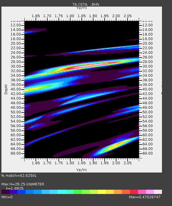
| Estimated Moho Depth: |
29.25 km |
| Estimated Crust Vp/Vs: |
1.89 |
| Assumed Crust Vp: |
6.597 km/s |
| Estimated Crust Vs: |
3.486 km/s |
| Estimated Crust Poisson's Ratio: |
0.31 |
|
| Radial Match: |
82.82581 % |
| Radial Bump: |
400 |
| Transverse Match: |
51.526287 % |
| Transverse Bump: |
400 |
| SOD ConfigId: |
2564 |
| Insert Time: |
2010-03-07 03:01:14.221 +0000 |
| GWidth: |
2.5 |
| Max Bumps: |
400 |
| Tol: |
0.001 |
|

Signal To Noise
| Channel | StoN | STA | LTA |
| TA:C07A: :BHN:20070330T16:10:38.424006Z | 0.666666 | 1.0482798E-7 | 1.5724214E-7 |
| TA:C07A: :BHE:20070330T16:10:38.424006Z | 0.84794813 | 1.5578708E-7 | 1.8372242E-7 |
| TA:C07A: :BHZ:20070330T16:10:38.424006Z | 2.3619046 | 5.190395E-7 | 2.1975464E-7 |
| Arrivals |
| Ps | 4.1 SECOND |
| PpPs | 13 SECOND |
| PsPs/PpSs | 17 SECOND |


