You are here: Home > Network List > TA - USArray Transportable Network (new EarthScope stations) Stations List
> Station A09A Danville, WA, USA > Earthquake Result Viewer
A09A Danville, WA, USA - Earthquake Result Viewer
| Earthquake location: |
Kuril Islands |
| Earthquake latitude/longitude: |
45.8/150.1 |
| Earthquake time(UTC): |
2007/09/03 (246) 16:14:53 GMT |
| Earthquake Depth: |
94 km |
| Earthquake Magnitude: |
6.3 MB, 6.2 MW, 6.2 ME |
| Earthquake Catalog/Contributor: |
WHDF/NEIC |
|
| Network: |
TA USArray Transportable Network (new EarthScope stations) |
| Station: |
A09A Danville, WA, USA |
| Lat/Lon: |
48.98 N/118.59 W |
| Elevation: |
931 m |
|
| Distance: |
58.2 deg |
| Az: |
50.81 deg |
| Baz: |
304.677 deg |
| Ray Param: |
0.06273014 |
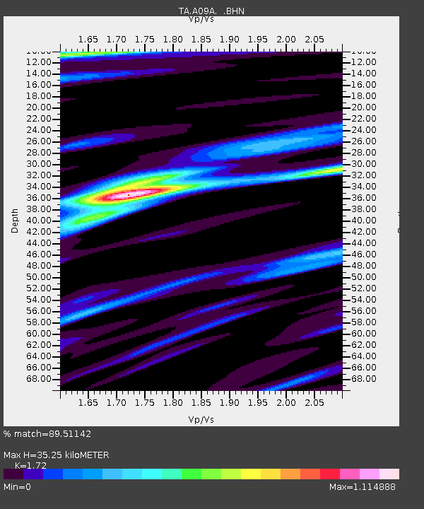
| Estimated Moho Depth: |
35.25 km |
| Estimated Crust Vp/Vs: |
1.72 |
| Assumed Crust Vp: |
6.419 km/s |
| Estimated Crust Vs: |
3.732 km/s |
| Estimated Crust Poisson's Ratio: |
0.24 |
|
| Radial Match: |
89.51142 % |
| Radial Bump: |
393 |
| Transverse Match: |
74.72118 % |
| Transverse Bump: |
400 |
| SOD ConfigId: |
2564 |
| Insert Time: |
2010-03-07 03:02:04.057 +0000 |
| GWidth: |
2.5 |
| Max Bumps: |
400 |
| Tol: |
0.001 |
|

Signal To Noise
| Channel | StoN | STA | LTA |
| TA:A09A: :BHN:20070903T16:24:07.225029Z | 11.9032 | 9.653793E-7 | 8.11025E-8 |
| TA:A09A: :BHE:20070903T16:24:07.225029Z | 13.999479 | 1.2399429E-6 | 8.857065E-8 |
| TA:A09A: :BHZ:20070903T16:24:07.225029Z | 35.692062 | 3.0336466E-6 | 8.4994994E-8 |
| Arrivals |
| Ps | 4.2 SECOND |
| PpPs | 14 SECOND |
| PsPs/PpSs | 18 SECOND |


